Intro to QGIS User Interface
|
Launch QGIS
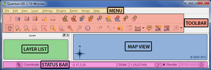
- MENU BAR provides access to all the functions and plugins
- TOOLBAR provides one-click common functions
- LAYER LIST shows all data layers currently added to the project
- MAP VIEW provides a dynamic visualization of the active data layers that can be mapped
- STATUS BAR provides some vital information about the current project settings
Explore the MENU BAR
- FILE menu is for Opening, Saving, Printing the data layers, and closing the current project
- EDIT menu is for adding, modifying, deleting spatial features within an editable data layer
- VIEW menu is for primary Pan, Zoom, Feature Selection, and Toolbar Controls
- LAYER menu is for Adding, Removing, Visibility of data layers, and for changing Layer Projections
- SETTINGS menu controls the basic Project settings, Project projection, Language Locale, & other defaults
- PLUGINS menu lists the installed Plugins and their sub-routines, and can Add or Remove Plugins
- RASTER menu is for Raster processing functions (more are enabled with GRASS)
- VECTOR menu is for standard Vector GIS spatial operations -- buffering, dissolving, point-in-polygon query, etc.
Proceed to TOOLBAR instructions |
