Projections: Coordinate Reference Systems
|
In QGIS the default projection, or CRS, is WGS84 Geographic Coordinate System. This CRS has become a global standard for latitude and longitude positions, such as those captured with GPS devices. Note that "unprojected" data, or those with projections that cannot be interpreted will be projected by default in WGS-84 when using QGIS. It is possible to load layers with different CRS into a QGIS project and view them seamlessly in the same coordinate space. This exercise will introduce the basics of managing CRS in QGIS. See also Peter H. Dana's Map Projection Overview .
- From the Menu go to SETTINGS | PROJECT PROPERTIES and click on the CRS tab
- Note the checkbox for enabling "only the fly" CRS transformations
- The CRS Selection Panel shows the current project CRS, and other pre-set CRS to choose from
- Next is a proj4 text panel, where projections can be set by pasting in proj4 format CRS statements. [You can look up proj4 statements by EPSG number at SpatialReference.org
- The Search by CRS Name panel provides a drop-down selection of the main Projection Authorities, such as EPSG, and a form to search for a name or ID number within that authority list.
- You can also select from Recently Used projection settings.
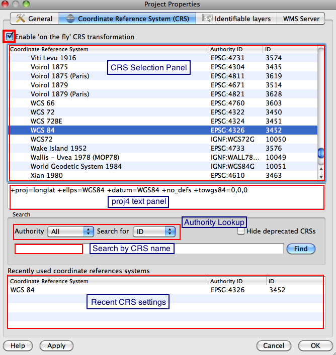
Note: in QGIS the current project CRS is always indicated in the lower right corner of the STATUS BAR.
- For this exercise, UNCHECK the "on the fly" transformations setting and click OK.
- Add Vector Data and browse to the SPAIN sample data, then OPEN.
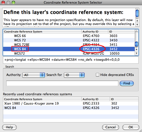
- Right-click on the layer in the list and select SET LAYER CRS
- CRS of active layer will be shown highlighted in the CRS list, followed by proj4 statement
- If desired, you can reset the CRS of the active layer here
- For now, we will CANCEL and add another layer in a different projection
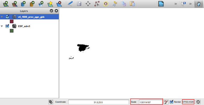
- Add Vector Data and browse to the CHINA sample data [v4_1820_prov_pgn layer], set encoding to GBK, then OPEN.
- Right-click on the v4_1820 layer in the list and select SET LAYER CRS
- Note the China data is in a different CRS: Xian 1980 Zone 19, or EPSG:2333. Click CANCEL.
- Now click on the ZOOM OUT tool and begin clicking the map to the east of Spain. As the view zooms out, you should reach a point (at scales above 1:50,000,000) where China should be visible. However, even though the China layer is both CHECKED as visible, and is ACTIVE, it is not shown in the current MAP VIEW. QGIS respects the layer CRS, unless you set the system to transform added layers on-the-fly to mesh with the current project CRS.
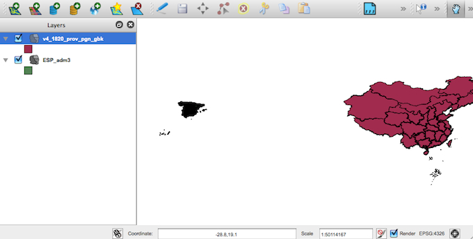
- Now go the menu SETTINGS | PROJECT PROPERTIES and CHECK the "on the fly" transformation setting, and OK
- The China Layer should now be visible! That is because the WGS84 is a global geodetic system projection, and the Gauss-Kruger projection was transformed to mesh with the WGS84 project CRS setting.
- Now let's try this process from the opposite direction. First, right-click on the SPAIN layer and REMOVE.
- Go the menu SETTINGS | PROJECT PROPERTIES and UNCHECK the "on the fly" transformation setting, and OK
- The China Layer should now vanish. Why? Because on the fly transform has been disabled, and the China Layer CRS (EPSG:2333) is NOT the same as the project CRS (EPSG:4326).
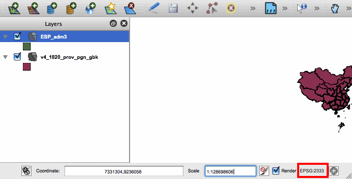
- Now right-click on the China layer and ZOOM TO EXTENT. We can now see the China data in the Xian 1980 Zone 19 projection.
- Go to the menu SETTINGS | PROJECT PROPERTIES and under Search, set AUTHORITY = EPSG, and search for = ID, type "2333" into the form, then click FIND
- You should see the current CRS highlighted as "Xian 1980 / Gauss Kruger Zone 19", or EPSG:23333. Accept this as the Project CRS by clicking OK.
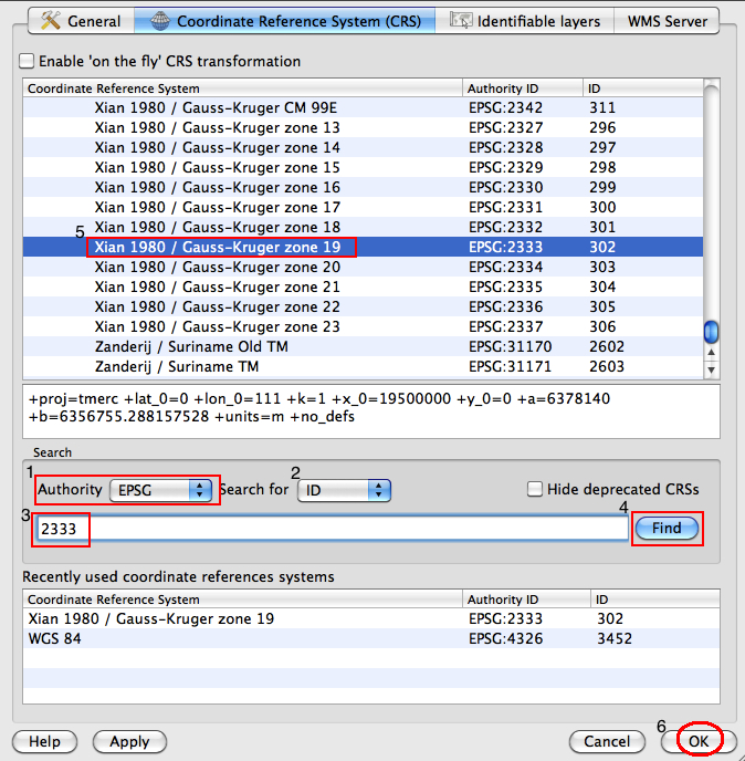
Check the QGIS STATUS BAR to make sure the Project CRS is now set to EPSG:2333
- Go to menu SETTINGS | PROJECT PROPERTIES and UNCHECK the "on the fly" transform setting.
- Add Vector Data and browse to the same SPAIN layer, then OPEN.
- Click the ZOOM OUT tool then click on the MAP VIEW to zoom to 1:50,000,000 scale or higher.
- Click the PAN tool and position China on the right side of the MAP VIEW. Spain is not visible.
- Go to menu SETTINGS | PROJECT PROPERTIES and CHECK the "on the fly" transform setting, OK.
- Spain is still NOT visible. Why? Because the Xian 1980 Zone 19 CRS is not a meant to be a global CRS, it cannot properly transform the SPAIN projection to mesh with its parameters.
Most Projected Coordinate Systems are meant for specific areas or purposes. WGS84 was meant to provide a global framework for geodata, and is therefore a reasonable default setting for CRS.
|
