19th Century German Electoral Map Conversion

German electoral boundaries from a 19th Century map were converted to vectors, built into polygons, and attributed. These were used to visualize 19th Century German census voting patterns. Service provided for Daniel Ziblatt, FAS – Political Science.

no links

Files:
german_electoral_boundaries1-1.jpg
german_electoral_boundaries2.png

Share

Mapping the US Southeast Region during the Civil War

This project generated digital vector data sets from detailed paper map of the Confederate States.

The digitizing of the maps was performed by an outside vendor, East View.

The CGA managed the correspondence with the vendor and performed quality assurance and quality control reviews of the resulting digital vector files.

CGA staff also built a web-based application for query, viewing and basic analysis of this data set.


no links

Files:
civilwar_11.gif

Share

Mapping a Way Forward - London, England

Consulting, data mining, and training was provided for this project that created a report on how GIS and spatial analysis can help efforts of the Lambeth Endowed Charities, London.

no links

Files:
mapping_a_way_london_resized.png

Share

Calculating driving distances between nursing homes and hospitals in NY

This study examines the predictors and implications of hospitalizations to nursing homes in New York State. Among many other predictors, the CGA takes responsibility for geographical distance calculation between nursing homes and hospital facilities.

For this project the CGA geocoded the addresses of hospitals and nursing homes, and then performed network analysis to calculate driving distances between nursing homes and hospitals.


no links

Files:
driving_11.gif

Share

Modeling Population Distribution in Chinese History

Chinese population data go back 2000 years. The challenge was to distribute this population across the landscape in a manner that most likely reflects patterns of settlement, rather than assuming that population density within an administrative unit is uniformly distributed.

For this reason, an automated model was created for combining political and physical geography. Using SRTM data, this model generated slopes and stream flows which, when taken together with the locations of administrative seats from the China Historical GIS project and historical population data, provided a means of distributing population.

Testing with far more detailed contemporary data has shown that the model can predict settlement patterns with a very high degree of accuracy.

Much in history is directly tied to the spatial distribution of population, the most important resource governments had available to them.

no links

Files:
zhejiang_11.gif

Share

Sea Level Change with Global Warming

The animation below (click on the image to see the effect) shows the potential change in sea level with global warming, and the impact that would have on coastal morphology. The animation begins at current sea level, and progresses to 1 meter rise, through 3, 6, 9, and finally to a 12 meter rise in sea level.

no links

Files:
sea_level1.gif

Share

2006 CGA Conference - Harvard Returned to Geography

On May 5, 2006, Harvard Returned to Geography under a bright spotlight. Some say it was Geography that Returned to Harvard. Certainly the presence of the past, present, and next presidents of the AAG showed that at least some geographers were coming to Harvard, if only for a day. The presence of David Maguire and Jack Dangermond from ESRI made clear that this event was not being ignored by the GIS software industry either. But the reality is that our efforts will continue to depend on each one of us in the geographic analysis profession to build on what we have already created, so that geographic analysis will contribute to excellence in teaching and research of many disciplines.

2006 CGA Conference Pressentations

History and Revival of Geography at Harvard

Geospatial Analysis Across the Disciplines

The Future of GIS

  • Introduction of ESRI President Jack Dangermond 
    Video presentation 
    Peter Bol

  • Closing Remarks 
    Video of presentation: Part I,   Part II 
    Jack Dangermond, President, ESRI


2006 CGA Conference Posters


Additional Reference Materials

  • See the Complete coverage on Harvard Gazette.

  • See photos of the launch event

     
    Larry Summers, President, Harvard University

  • Peter Bol received the
    ESRI Award for Contributions to Geographic Science 
    from Jack Dangermond, President of ESRI
    at the lauch event.


no links

no file attachments

Share

Digitization of Maps of Ife, Nigeria

The CGA assisted with the development of digital vector files based on detailed planimetric maps of Ife, Nigeria.

no links

Files:
ife_digitized1.jpg
ife_original1_resized.jpg

Share

Mapping the Record of American Democracy (ROAD) 1984-1990

Poster presentation on the 26th ESRI International Conference, San Diego, CA. August 7-11, 2006.

Links:
View the poster

no file attachments

Share

The Effects of Protected Forest Areas on Local Economic Development in Villages of Chiang Mai Province, Thailand

In response to concerns about deforestation and habitat loss, many countries around the globe have set aside large tracts of land with special conservation status. However, in many instances such lands are home to existing human settlements, agriculture, or timber production.

Clearly, environmental policies have the potential to change patterns of land use, employment, and economic growth. However, little is currently known about the actual direction and magnitude of the economic effects of protected areas policies on existing or nearby human settlements, particularly in developing countries. In particular, do protected areas policies significantly change the pace of economic growth for populations inside or near these areas, compared to similar settlements that do not have protected status? If so, what is the magnitude of the difference, and what are the mechanisms that seem to dominate in explaining the effects?


This project analyzes how protected area policies have affected economic development in the context of villages in Chiang Mai Province in Northern Thailand. I compare the growth of selected household assets and employment rates for villages inside and outside different types of designated forest protection areas over a period from 1986-2003, using bi-annual survey data from the Thai Community Development Department.<\p>

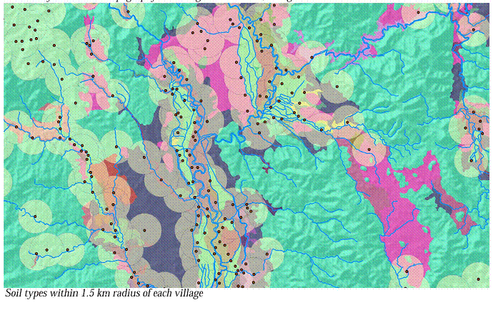
Geospatial data plays an important role as the researcher seeks to choose villages in the comparison or “control” group that are similar in terms of geographic characteristics (including elevation, slope, soil type, and proximity to major water bodies) to those villages that are inside of protected areas.<\p>

The project calculated five geographic data variables for roughly 1,500 villages in the Chiang Mai province. The data variables sought for each village are:

1. Average Elevation within 1.5 km radius
2. Average Slope within 1.5 km radius
3. Soil type
4. Distance to closest major river or perennial stream
5. Distance to border of nearest conservation area.

<\p>

Final deliverables include a table with all the geographic variables and a technical procedure manual for the researcher to be able to repeat the process:<\p>

no links

Files:
chiangmai_21.gif

Share