Missing Unit Problem in Population Health (and Social Science) Research

Speakers: Rockli Kim, S.V. Subramanian

Date and Time:   Thursday Mar 15th,  12:00pm  -  1:30pm
Location:  CGIS South 354

Abstract:  An exclusive reliance on a single level – whether individual or geographic/ecological – as the unit of analysis is still pervasive in many fields of social sciences, including population health research. It is well recognized that patterns and relationships observed at any analytical unit is highly sensitive to the definition of the areal unit (i.e., “Modifiable Areal Unit Problem”). Yet, the fundamental premise in a single level framework, that there intrinsically exists one ideal unit of analysis and inference, is unrealistic given the complexity of the world we live in. While the advent of multilevel modeling provided opportunities to simultaneously model variation at multiple geographic scales, most studies in population health are restricted to two level of analysis at most. We present the thesis that treating observed differences in the results by choice of unit of analysis simply as a nuisance is conceptually problematic and can be empirically misleading (at worst) and in many instances provide an impoverished interpretation of the undertaken inquiry. The relative importance of one unit can be truly examined only when multiple scales that are thought to influence the outcome are simultaneously considered (i.e., “Missing Unit Problem”). In order to exemplify our thesis, we present our work concerning variously defined levels and a range of health outcomes (life expectancy, BMI, child anthropometric status and failures) in the context of the US and across low- and middle-income countries. 

Speaker Bios:

Rockli Kim is a postdoctoral research fellow at Harvard Center for Population and Development Studies. She received her ScD from the Department of Social and Behavioral Sciences and SM from the Department of Global Health and Population at the Harvard T.H. Chan School of Public Health. Her current research work focuses on investigating variations in individual and population health and well-being using multilevel statistical modeling. Additional research interests include assessing social determinants of child undernutrition and early childhood development in low- and middle-income countries.

S.V. Subramanian is a Professor of Population Health and Geography at Harvard University. He was the Founding Director of Graduate Studies for the interdisciplinary PhD program in Population Health Sciences at Harvard. He has published over 500 articles, book chapters, and books in the field of social and contextual determinants of health and nutritional inequalities in India and developing countries, and applied multilevel statistical models. He was named among Thomson Reuters Highly Cited Researchers (top 1% of cited publications in Web of Sciences) in 2015, 2016, and 2017. Subramanian is the Co-Editor-in-Chief for the international journal Social Science & Medicine (SSM), a Co-Senior Editor for the social epidemiology office of SSM, and the founding Co-Editor-in-Chief of a new journal SSM – Population Health.


no links

no file attachments

Share

January 2018

CGA Newsletter January 2018 PDF (Download)

HIGHLIGHTS
CGA NEWS

Drone Imagery in ArcGIS, a one-time Workshop will be held 1pm-5pm on February 23rd, 2018. Cody Benkelman, Technical Product Manager for Imagery at ESRI will lead the workshop and answer your questions. For more information and to Register please visit the workshop webpage

Both the 2018 Fisher Prize for excellence in GIS and the ESRI EDC Student of the Year Award are open for applications from Harvard students.

Read more about applying for both prizes.


CGA FACULTY AFFILIATE PUBLICATIONS

“How to Measure Legislative District Compactness”.
Authors: Aaron Kaufman (Harvard, IQSS), Gary King (Harvard, Dept of Government), Mayya Komisarchik (IQSS)
Published by: Working Paper (November 2017)
PDF available

“Claiming Crimea, A History of Catherine the Great’s Southern Empire”.
Author: Kelly O’Neill (Harvard, Dept of History).
Published by: Yale University Press (November 2017)
Description and Table of Contents

HARVARD GIS COMMUNITY NEWS

Harvard DataFest 2018 will be held Jan 17th - 18th Registrations are open! CGA will present geospatial data topics, such as PostGIS, R Scripts in QGIS, and WorldMap. See more on the DataFest Schedule

Harvard Map Collection Map Story: Look But Don’t Touch: Tactile Illusions on Maps in conjunction with a map exhibit on Jan 10th, the Map Collection has created an ESRI Map Story


CONFERENCES, CALLS & JOBS

Job: GIS Technician Commonwealth of Massachusetts [posted 21 Dec 2017] Read more

Call for Papers: FOSS4G 2018 (Aug, 27-28) Dar es Salaam Open call for presentations until March 21st, 2018. Read more


NEWS ON GIS RESEARCH AND SERVICES
 

Mapping the Cyclone Bomb Storm (NASA Earth Observatory)

Bare Essentials, LIDAR Map Story (Washington Geological Survey)

Bitcoin Purchases Live Map

Debt in America Interactive Map (Urban Institute)

Jack and Laura Dangermond Preserve Point Conception with Major Gift to The Nature Conservancy

URISA Salary Survey for GIS Jobs, 2017

GIS in Interdisciplinary Research [Geo: Geography and Environment, 2017; 4 (2), e00046]

MapZen announces closure


The CGA Newsletter is published monthly. Editor of this issue: Lex Berman.

Happy New Year, 2018!


no links

no file attachments

Share

Mapping Bears Ears National Monument

Considerable controversy surrounds the areas designated for protection in Southeastern Utah, which have culminated in two Presidential Proclamations.  

The first proclamation (Dec 28th, 2016), was made by President Barack Obama, who had been petitioned in a joint effort of five Native American Nations to establish federal protection over those lands.   In the petition, a partnership of the Native American governments defined 1.9 million acres of land that encompassed many thousands of archeological and culturally significant sites. (1)    Obama’s Proclamation (#9558) was made under the auspices of the Antiquities Act, and decreed an area of 1.35 million acres to be established as the Bear’s Ears National Monument.  (2)

According to an article published in the Atlantic at the time of Obama’s enactment, a group of Republican lawmakers were enraged that this was done by “a lame duck” President. (3)  Unsuccessful in getting their own legislation passed to preserve parts of the same area, they vowed to undo Obama’s legacy.

One year later, on Dec 4th, 2017,  President Donald Trump has done exactly that with his own proclamation (#9681), which makes the case that it was not necessary to reserve such a large area to preserve historical sites that are already protected by other statues.  With a stroke of his pen, Trump has removed over 1 million acres from the Bears Ears National Monument lands, reducing the protection to some 200,000 acres. (4)

How can we go about mapping this situation?   And how does this relate to the management of these lands, and the public claims process by which mining interests or others might stake a claim on these lands?

With these questions in mind, we called the National Offices of the Bureau of Land Management and spoke with Christopher McAlear, Assistant Director, Office of National Conservation Lands and Community Partnerships.   Mr. McAlear cheerfully explained some of the more general aspects of the situation, which are also documented on the BLM website.   (5)

We found that the current press reports about the million acres of lands being opened to exploration and staking of claims, is true to the extent that the Trump proclamation has reduced the size of Bears Ears National Monument from 1.3 million acres to 200,000 acres.   However, to take this in context, the BLM manages more than 245 million acres of lands found in 12 Western states, with an additional 700 million acres of subsurface rights over which it has jurisdiction.   Therefore, the Obama proclamation had protected the equivalent of 0.5% of the BLM lands.  

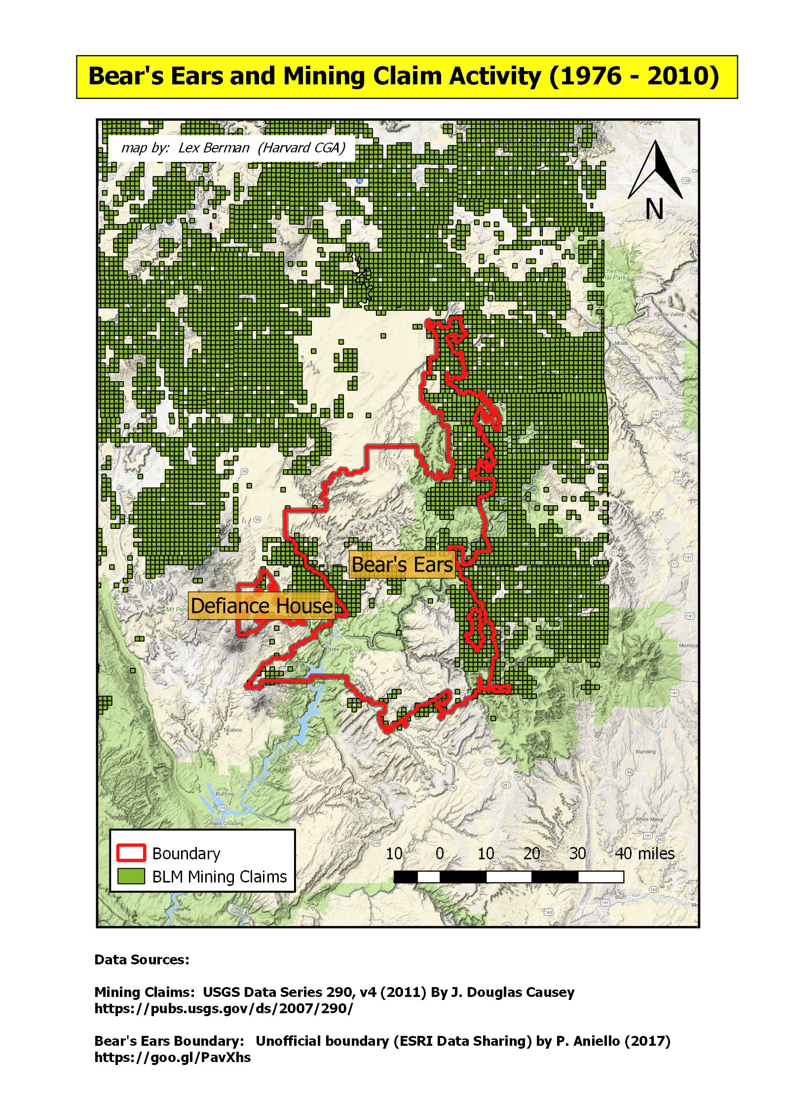
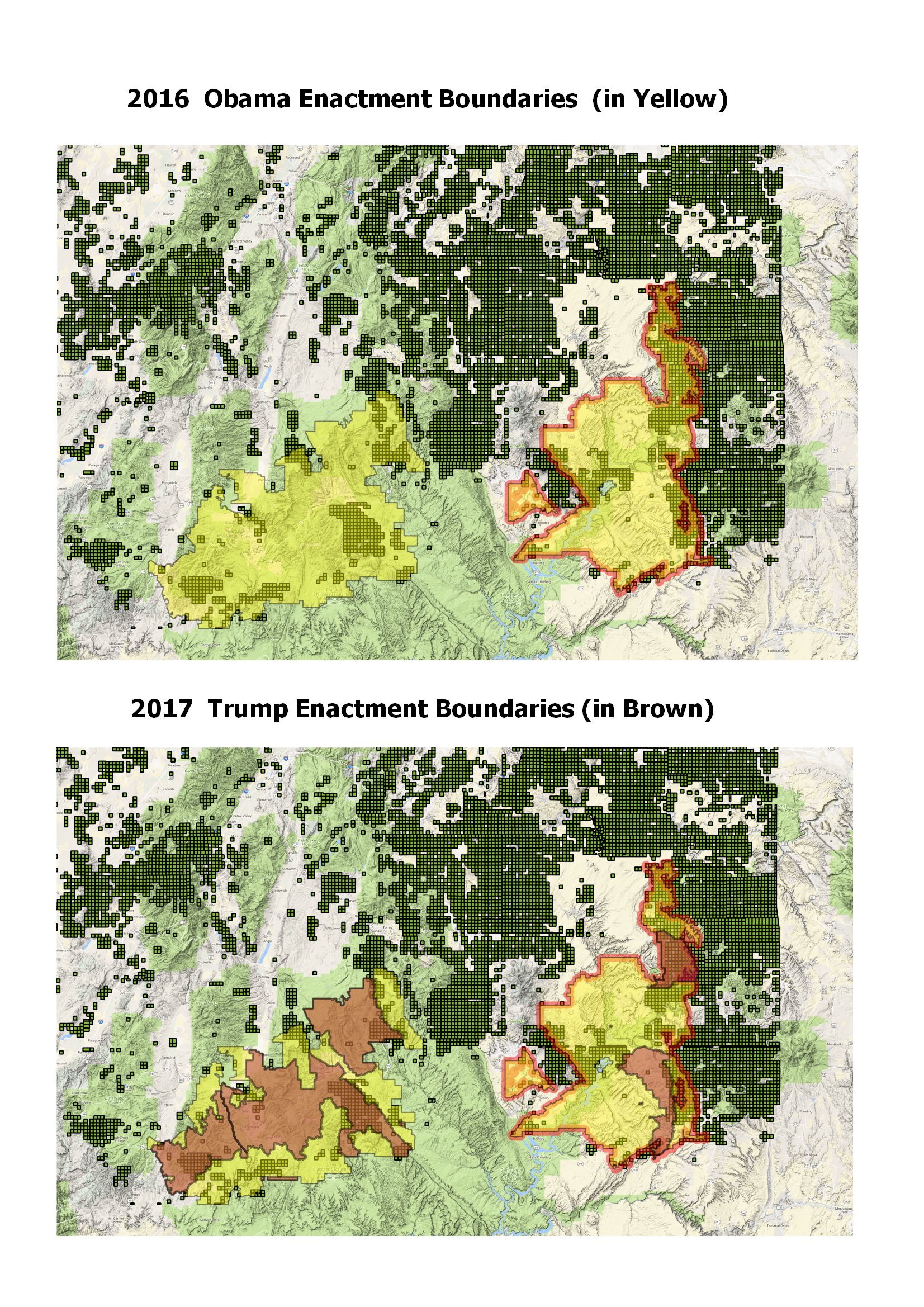
Indeed, if we take a look at the Obama monument boundary (an unofficial version published on ESRI data sharing geonetwork) (6), we can see that it covers about 75% of the area requested in the petition from the coalition of Native American Nations.   Overlayed onto a dataset of all public land claims recorded by the BLM (from 1997 – 2010), we can see that there have been considerable stakes claimed in the area that was protected by the Obama proclamation.  (7)

Map of the Obama designated Bears Ears Monument overlayed on mining claims from the Bureau of Land Management

The boundary modification that Trump has enacted is seen in the following Dept of Interior map. (8)


Map of Bears Ears boundary as modified by Trump


The BLM have provided the official datasets for these boundary changes on their BLM Navigator website.   (A big thank you to all the BLM staff for following up on our request!)

Obama National Monument Extent:   https://navigator.blm.gov/data?keyword=2613aa2c551c96bv 

Trump National Monument Extent:   https://navigator.blm.gov/data?keyword=7385ceff45d68adb

two maps comparing the Obama 2016 boundaries with Trump 2017 boundaries

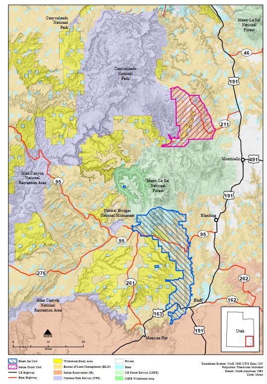
The boundaries, as revised by the Trump enactment, have obviously reduced the Bears Ears section of the protected area to the original extents of the Indian Creek National Monument (in the North) and the Shash Jaa National Monument (in the South).

According to the official press release from the Dept of the Interior, the modification of the boundary was made in consultation with the area stakeholders, including the Tribal representatives from the alliance that had original petitioned President Obama.  (9)

Regardless of the official pronouncements and the current press surrounding Bears Ears, the mapping of the situation should take into consideration other factors, in particular a more thorough summary of the current mining claims that overlap both the Obama and Trump protected lands.  

For example, Daniel Brownstein has an extensive report on Bears Ears that is worth further analysis. (10)   In his report, Brownstein points to many mineral deposits, in particular Uranium deposits, as reported in the Washington Post (11).


Map of Uranium development potential in Bears Ears area, Washington Post

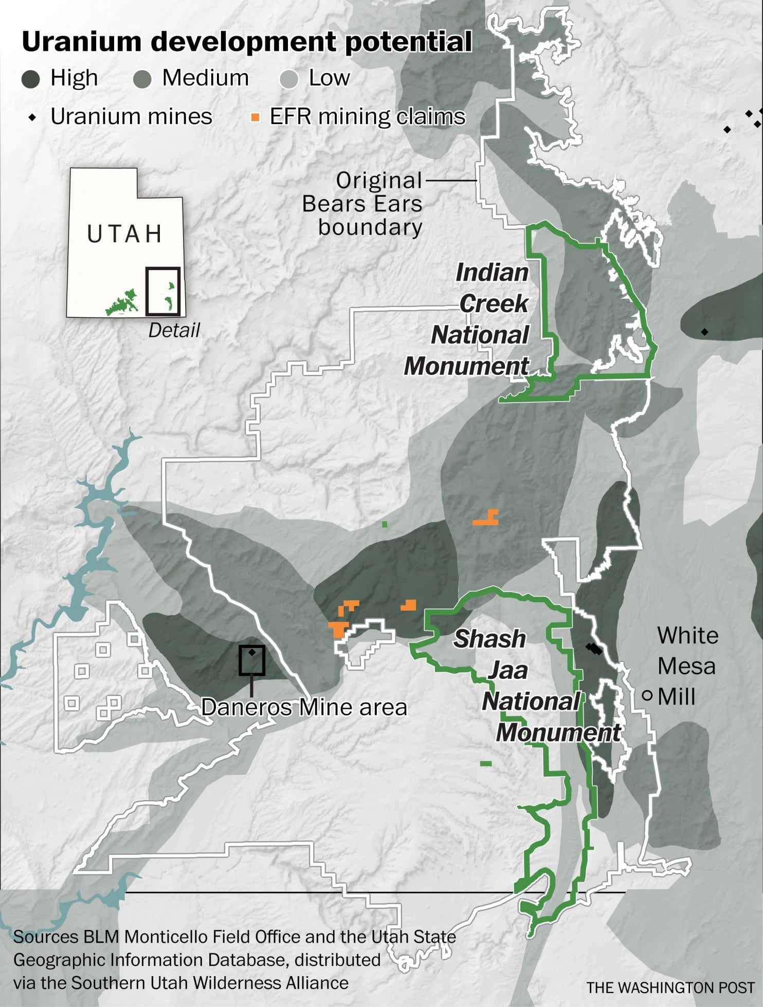
It is worth noting that the Obama encacted boundary also did not include the area of the Daneros Mine Area, which is not contained by the White border shown in the Washington Post map.   But the Trump revision, by falling back to the earlier Indian Creek and Shash Jaa National Monuments no longer includes large swathes of potential uranium and oil deposits.

Do these maps reveal potential conflicts of interest between the establishment of National Monuments and mining interests?  If not, why has the enlargement of the Bears Ears National Monument protected lands been swiftly reversed?

Perhaps more importantly, if Bears Ears National Monument only represents 0.5% of the BLM managed lands, what is going on in the other 99.5% of those 245 million acres?   Does the public have any access to the data, or a right to know how our federally administered lands are being developed?  

The BLM is doing a great job of publishing the geographic extents of protected lands.   We hope that data related to the current claims and leases on those lands will also be available for further analysis, in order to answer some of the questions we have posed above.

References:

(1)  TRIBES FORMALLY PRESENT BEARS EARS PROPOSAL TO OBAMA ADMINISTRATION  (Southern Utah Wilderness Alliance,  Autumn / Winter 2015)   https://suwa.org/tribes-formally-present-bears-ears-proposal-to-obama-administration/

(2)  Presidential Proclamation – Establishment of the Bears Ears National Monument  https://obamawhitehouse.archives.gov/the-press-office/2016/12/28/proclamation-establishment-bears-ears-national-monument

(3)  “Obama’s Environmental Legacy, in Two Buttes” by Robinson Meyer.  (The Atlantic, Dec 30th, 2016)  https://www.theatlantic.com/science/archive/2016/12/obamas-environmental-legacy-in-two-buttes/511889/

(4) Presidential Proclamation - Modifying the Bears Ears National Monument https://www.whitehouse.gov/presidential-actions/presidential-proclamation-modifying-bears-ears-national-monument/

(5) BLM Bears Ears National Monument  https://www.blm.gov/programs/national-conservation-lands/utah/bears-ears-national-monument

(6) Bears Ears National Monument (as decreed by President Obama in Dec. 2016), unofficial boundary by P. Aniello (2017)  https://goo.gl/PavXhs

(7)  “Mining Claim Activity on Federal Land in the United States,”  By J. Douglas Causey (U.S. Geological Survey, Data Series 290, Version 4.0, 2007, revised 2011)  https://pubs.usgs.gov/ds/2007/290/

(8)  Bears Ears Monument Boundary Modification   https://www.doi.gov/sites/doi.gov/files/uploads/benm_12012017.pdf

(9)  President Trump and Secretary Zinke Announce Modification to Utah Monuments  https://www.doi.gov/pressreleases/president-trump-and-secretary-zinke-announce-modification-utah-monumentsresulting-5

(10)  “Clipping Bears Ears,” by Daniel Brownstein.  Musings on Maps (Dec 5th 2017)  https://dabrownstein.com/2017/12/05/bears-ears/

(11)  “Uranium firm urged Trump officials to shrink Bears Ears National Monument,” by Juliet Elperin in Washington Post (Dec 8th 2017)   https://www.washingtonpost.com/national/health-science/uranium-firm-urged-trump-officials-to-shrink-bears-ears-national-monument/2017/12/08/2eea39b6-dc31-11e7-b1a8-62589434a581_story.html?utm_term=.30fe69bbece9

 (12) “The feds want to give $14 million in taxpayer money to a Koch brother’s coal mine” by Katie Herzog.  Grist (Jan 13th, 2016)  https://grist.org/article/the-feds-want-to-give-14-million-in-taxpayer-money-to-a-koch-brothers-coal-mine/


 reported by Lex Berman  (2018-02-01)


no links

no file attachments

Share

Introduction to GIS for the course Critical Analysis of Environmental Systems

Guest lecture on GIS for environmental studies to a class of Master’s students in the Extension School’s Environmental Sustainability program. 

Links:
ENVR E-210 (13757) Syllabus

no file attachments

Share

Strategic Data Project Joint Winter Workshop 2018

 This is an introduction to GIS workshop for the Fellows in the Strategic Data Program run by the Harvard Graduate School of Education Center for Policy Education Research.  The workshop will be taught at the Joint Winter Session in New Orleans on January 31, 2018.

Download Workshop Materials

View a PowerPoint file with student created maps

no links

no file attachments

Share

ANTHRO 2020 - GIS & Spatial Analysis In Archaeology

An introduction to the GIS and remote sensing methods used by archaeologists to document and analyze datasets at the regional scale. This class will involve the hands-on use of maps, aerial photography, satellite imagery, digital terrain models and GPS-based observations to frame and approach archaeological research questions. Labs will use sample datasets from a variety of regions but students will be responsible for assembling a GIS database for their own region of interest.   Register here.

no links

no file attachments

Share

SCI 6322 - Mapping - Geographic Representation and Speculation

Maps do not represent reality, they create it. As a fundamental part of the design process, the act of mapping results in highly authored views of a site. By choosing what features, forces, and flows to highlight – and implicitly, which to exclude – the designer first creates the reality into which their intervention will be situated and discussed.  Over the course of a semester, students will work extensively with techniques of geospatial analysis in GIS. Using ESRI’s ArcMap software, we will explore data sources, data models, topological overlays, map algebra, spatial statistics, terrain analysis, and suitability modeling, among others. Students will learn how to embed these techniques within larger design workflows. We will address the visualization of spatial analysis in its various forms using Illustrator, Photoshop, and physical modeling. We will also treat mapping as an active part of the design process - where the speculative use of spatial data provides the context for 2D and 3D design proposals in Rhino. These designs will then feed back into the GIS environment as additional layers for analysis and modeling. Lastly, a portion of the semester will be devoted to visualizing geospatial data using the Processing language. The basics of coding with Processing will be taught with a specific focus on representing analysis produced by students in the GIS environment. Course Structure Each week will consist of a skills workshop devoted to a technique or workflow, and a lecture that situates these techniques critically in relationship to design. Students will be expected to complete weekly mapping exercises and short reading assignments in preparation for the class. During the semester, there will be two main projects combining advanced mapping techniques with a student’s own research interests. Prerequisites No previous experience with ArcMap or Processing is assumed. Confidence with Rhino, Adobe Illustrator and Photoshop is preferred.   See Course Catalog Listing

no links

no file attachments

Share

GOV 1009 - Advanced Geographical Information Systems Workshop

This course is a workshop for students who have taken the introductory Geographical Information Systems course and want to explore detailed applications. The course will meet two times a week for a lecture and a laboratory exercise.   

See Course Catalog Listing

no links

no file attachments

Share

GHP 534 - Introduction to Spatial Methods for Public Health

This is an introductory level course in the conceptual and analytic tools used to understand how spatial distributions of exposure impact on processes and patterns of disease. It covers methods that allow: (i) examination of patterns of health and disease in place and time, (ii) application of geospatial technologies and methods for epidemiology, (iii) analysis of time-space relations, (iv) identification of clusters and diffusion of disease, and (v) study of geographical epidemiology of selected infectious and noninfectious diseases.Course Activities: Assigned readings must be read in advance of class. Students will help summarize and lead discussions on several papers; complete a term project.Students are highly encouraged to take one of the workshops on ArcGis offered by the Center for Geographical Analysis (CGA) - http://www.gis.harvard.edu.       See Course Catalog Listing

no links

no file attachments

Share

ISMT E-150 - Introduction to GIS

This course introduces the concepts and components of a geographic information system (GIS). It also teaches the essential skills of spatial data management, analysis, and visualization through the use of the ArcGIS software package. Upon completion of this course, students understand the fundamental concepts of a GIS including spatial data models, spatial analysis, and cartographic principles. They also gain hands-on training in spatial data collection, editing, transformation, and mapping, as well as spatial analysis operations such as location-based query, address geocoding, terrain and watershed analysis, spatial interpolation, best site selection, least cost path delineation, and a number of other GIS modeling techniques. GIS technology has broad applications in the natural and social sciences, humanities, environmental studies, engineering, and management. Examples include wildlife habitat study, urban and regional planning, contagious disease monitoring, agriculture and forestry, environmental quality assessment, emergency management, transportation planning, and consumer and competitor analysis. This course introduces a few selected cases of GIS application in different disciplines.    See Course Catalog Listing

no links

no file attachments

Share