May 2018

CGA Newsletter May 2018 PDF (Download)

HIGHLIGHTS

CGA NEWS

CGA 2018 conference, Illuminating Space and Time in Data Science was held May 26-27, 2018. Audio Recordings of the Sessions are available on the Conference webpage. Reports on the conference have been posted by CGA and by David DiBiase (ESRI Director of Education). Photos of the conference are posted on Twitter under the hashtag #harvardgis

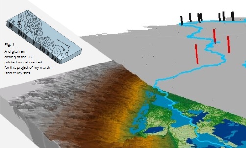
Winner of the 2018 Fisher Prize for Excellence in GIS [GSD Masters Candidate] is Yousef Awaad Hussein for his poster “Territory, Survey, Cartography – South China Sea” read more and see the poster PDF.

Winner of the 2018 Fisher Prize for Excellence in GIS [Undergraduate Student] is Jennifer Horowitz for her poster “A Spatiotemporal Analysis of Man-Made Ecocide: Saddam Hussein’s Reduction of the Southern Iraqi Marshes” read more and see the poster PDF.

HARVARD GIS COMMUNITY NEWS

Ash Center of Harvard Kennedy School has published a new DataSmart Resources guide on User-Centered Government, which provides excellent information on design of open data and communicating information to the public. See especially the NYCCivic Service Design Toolkit


CGA ASSOCIATE PUBLICATIONS

“Decoupling the effects of deforestation and climate variability in the Tapajós river basin in the Brazilian Amazon” 
Authors: Mauricio E. Arias, Eunjee Lee, Fabio Farinosi, Fabio F. Pereira, , Paul Moorcroft (Harvard EPS) 
Published by: Hydrological Processes (2018-04-06). https://doi.org/10.1002/hyp.11517
Full Text Online

“Land cover change explains the increasing discharge of the Paraná River” 
Authors: Eunjee Lee, Angela Livino, Shin-Chan, HanKe Zhang, John Briscoe, Jerson Kelman, Paul Moorcroft (Harvard EPS) 
Published by: Regional Environmental Change (2018-04-09). https://doi.org/10.1007/s10113-018-1321-y 
Full Text Online

CONFERENCES, CALLS & JOBS

Conference: 21st Map and Geoinformation Curators Group Conference (MAGIC 2018), affiliated with International Cartographic Association Commission Cartographic Heritage into the Digital. Gotha, Germany, October 8th-10th. Deadline for submissions:20 May 2018 Read more

Call for Papers: Special Issue “Special Issue: Discrete Global Grid Systems (DGGS)” in Cartographica Journal Deadline for submissions: extended to 31 May 2018 Read more

Call for Papers: 5th Special Issue on Spatial Ecology, IJGIS Deadline for submissions:July 15, 2018 Read more

NEWS ON GIS RESEARCH AND SERVICES
 

Global Trade Flows in 3D Map Visualization using WebGL [Datalabs]

In 83 Million Eviction Records, a Sweeping and Intimate New Look at Housing in America[NYTimes]

Resource Watch Data Repository and Web Maps [World Resources Institute]

15th Century Icunabula Story Map [Library of Congress]

3D Smart City Model of Boston [Boston Planning and Development Agency and ESRI]

PastMap Launches a new version [Historic Environment Scotland]

Tornado Migration, and Exercise for Visualization of Big Data [ESRI Story Map]

Waldo Tobler Memorial Planned at UCSB (May 25th, 2018)


The CGA Newsletter is published monthly. Editor of this issue: Lex Berman.

no links

no file attachments

Share

Enhancing discovery in spatial data infrastructures using a search engine

A spatial data infrastructure (SDI) is a framework of geospatial data, metadata, users and tools intended to provide an efficient and flexible way to use spatial information. One of the key software components of an SDI is the catalogue service which is needed to discover, query and manage the metadata. Catalogue services in an SDI are typically based on the Open Geospatial Consortium (OGC) Catalogue Service for the Web (CSW) standard which defines common interfaces for accessing the metadata information. A search engine is a software system capable of supporting fast and reliable search, which may use ‘any means necessary’ to get users to the resources they need quickly and efficiently. These techniques may include full text search, natural language processing, weighted results, fuzzy tolerance results, faceting, hit highlighting, recommendations and many others. In this paper we present an example of a search engine being added to an SDI to improve search against large collections of geospatial datasets. The Centre for Geographic Analysis (CGA) at Harvard University re-engineered the search component of its public domain SDI (Harvard WorldMap) which is based on the GeoNode platform. A search engine was added to the SDI stack to enhance the CSW catalogue discovery abilities. It is now possible to discover spatial datasets from metadata by using the standard search operations of the catalogue and to take advantage of the new abilities of the search engine, to return relevant and reliable content to SDI users.

Links:
PeerJ Computer Science

no file attachments

Share

March 2018

CGA Newsletter March 2018 PDF (Download)

A Monthly Publication of the CGA at Harvard University


HIGHLIGHTS
CGA NEWS

ESRI will hold two recruiting events at Harvard in March, 2018.

  • Thursday, March 22nd: Networking Session at CGIS South S030, 1-4:30pm
  • Friday, March 23rd: GSD Career Fair, Gund Hall, 10am-4:00pm
For More Information.

ESRI Demographic Datasets 2017 Update, are now available for use in the HMDC Computer Lab. For more information about the datasets visit this webpage

Geography Colloquium, Mar 15th, 2018: Missing Unit Problem in Population Health (and Social Science) Research Presenters: Rockli Kim, and S. V. Subramanian details and abstract

CGA 2018 conference keynote speakers announced

For Details and Registration.

GIS Institute Summer 2018 application deadline on March 16th

For Details and Application.

Both the 2018 Fisher Prize for excellence in GIS and the ESRI EDC Student of the Year Award are open for applications from Harvard students.

Read more about applying for both prizes.

HARVARD GIS COMMUNITY NEWS

On Foot in the Path of the Silk Road is a new Story Map describing the continuing journey of Paul Salopek, as he continues his seven year “slow journalism” trek around the world. Explore the Story Map
CGA’s Jeff Blossom provides support for Out of Eden Walk’s GPS mapping and Cartography.

CGA ASSOCIATE PUBLICATIONS

“Estimating the Spatial Distribution of Crime Events around a Football Stadium from Georeferenced Tweets”
Authors: Alina Ristea, Justin Kurland, Bernd Resch (Univ Salzburg), Michael Leitner, Chad Langford
Published by: ISPRS Int. J. Geo-Inf. February 2018, 7, 43; doi:10.3390/ijgi7020043
Full Text Online

“Island Formation Resulting From Radially Symmetric Flow Expansion”
Authors: John B. Shaw (Harvard EPS), Kimberly Miller, Brandon McElroy
Published by: ISPRS Int. J. Geo-Inf. February 2018, 7, 43; doi:10.3390/ijgi7020043
Full Text Online

CONFERENCES, CALLS & JOBS

Call for Papers: Site Magazine: Foundations and Disruptions (Digitization of Urban Space) Deadline for submissions: 1 Apr 2018 Read more

Call for Papers: 1st Intl Workshop on Spatial Language Understanding (June 6 2018) New Orleans, LA Deadline for submissions: 15 Apr 2018 Read more

Call for Posters: GeoEd Conference, June 4-8th, 2018, Louisville, KY Invites Undergraduates to enter the 2018 Geospatial Technology Skills Competition. Winners will be awarded registration, travel, and accomodation expenses to attend GeoEd 2018. Deadline for Poster Submissions: 20th Apr 2018 Read more

Call for Papers: Digital Heritage 2018 (26-30 Oct 2018) San Francisco, CA Deadline for submissions: 15 Apr 2018 (Sessions), 20 Apr 2018 (Papers) Read more

Call for Papers: FOSS4G Asia (Dec 2-5 2018) Moratuwa, Sri Lanka Deadline for submissions: 1 May 2018 Read more

Job: Fellowship Programs at AZAVEA Philadelphia, PA. Paid 12 week Fellowships. [Closing Date: 11 Mar 2018] Read more

Job: Spatial Data Architect Smith College, Northampton, MA [Closing Date: Mar 30, 2018] Read more

NEWS ON GIS RESEARCH AND SERVICES
 

DataShine, Big Open Data Mining and Synthesis [UCL London]

Court ordered redistricting in Pennsylvania: before and after maps [NYTimes]

Billions of Birds Migrate: Where do they go? [National Geographic]

20 Years of Global Hi and Low Temperatures, Map Animation [Flourish]

Press Release (Mar 7 2018) German consortium launches BigDataCube for petabyte spatio-temporal earth observation data using rasdaman [DirectionsMag]

Geography of the Italian Election Results [Corriere della Sera]

Mapping the Restaurants of NYC with Sanitation Inspection Data [Will Su, Mapbox]


The CGA Newsletter is published monthly. Editor of this issue: Lex Berman.

This newsletter passes on news items and information about new web maps or uses of GIS that come to the CGA’s attention from various sources. These are provided for informational purposes only. The CGA does not endorse these items and makes no representations about their accuracy, completeness or quality. © Present & Fellows Harvard University. All Rights Reserved.

no links

no file attachments

Share

Fisher Prize Award 2018 - Undergraduate Category

Poster title:  A Spatiotemporal Analysis of Man-Made Ecocide: Saddam Hussein’s Reduction of the Southern Iraqi Marshes

Judges comments: “A well executed quantitative historical analysis performed using appropriate GIS methods, presented in a visually appealing manner.”

no links

Files:
horowitz_ecocide.jpg

Share

Notes on the CGA Annual Conference 2018

Illuminating Space and Time in Data Science

was held at Harvard University, April 25th and 26th, 2017.   AUDIO recordings available here.

The 2018 Research Conference of Harvard’s Center for Geographic Analysis examined the convergence between geographic information science and data science. The two-day meeting, titled Illuminating Space and Time in Data Science, brought together academic and industry experts to discuss their perspectives on a range of new technologies and techniques for analysis and interpretation of the dynamics of everyday life, environmental monitoring, and the possibilities for greater civic engagement. This new era, sometimes referred to as big data or the internet of things or pervasive computing, marks a moment in which scientists, policy makers, and consumers have access to enormous datasets to make observations about the world, to plan for a sustainable future, or to purchase the most reliable appliances.

The rapid proliferation of ‘smart’ objects has enabled a variety of sensors operating at a wide range of scales – from the body to the planet – resulting in unprecedented volumes of digital data. Most readers of this text have the ability to record their location at this moment, and many are probably transmitting that location now, some consciously and some unconsciously. From satellite images to social media streams, from census and parcels to records of trade, food, energy, climate, disease, crime, conflicts, etc., big data with space and time signatures are essential for understanding our world and responding to its challenges.

The ramifications of the world’s expanding data are not purely academic. “Even ‘safe’ pollution levels can be deadly,” said Prof. Francesca Dominici, Director of the Harvard Data Science Initiative, in her morning keynote address at the event. Dominici’s research team analyzed terabytes of high-spatial resolution exposure and medical data through complex computations to study air pollution impacts on human health. Within the field of data science, “Spatial is special,” noted Michael Goodchild, Emeritus Professor of Geography at the University of California, Santa Barbara, in his luncheon keynote address.  Goodchild gave an overview of the landscape of geographic information science (GIScience) in which he emphasized that if data science is about prediction, then space and time enable prediction of where and when. Dominici and Goodchild headlined a day-and-a-half program with nearly 30 invited speakers, each exploring the interrelationships of space and time in data science before an audience of over 200 attendees.

The conference was co-organized by the Center for Geographic Analysis (CGA), the Harvard Data Science Initiative, and Esri, a global leading company in mapping and spatial data analytics technology. Co-sponsors included MapD Technologies, Inc. and NSF I/UCRC Spatiotemporal Innovation Center. Prof. Jason Ur, Director of the CGA, and Elizabeth Hess, Executive Director of IQSS, opened the program on Thursday and Friday respectively, both pointed out the need to explore relationship between data science and GIScience.

Four technical workshops on Thursday highlighted ongoing research and applications in spatiotemporal analytics from the co-organizers and co-sponsors, including work that showcased the use of National Water Model (NWM) Predictions, spatiotemporal methodologies and analytics for the study of extreme weather, the use of machine learning with GIS, and the visual analytics of big data.

Four panels on Friday discussed sensors and infrastructure, analysis and interpretation, applications and case studies for cities, health, and environment, and future directions and implications for civic engagement. The 20 panelists presented highlights of their research and addressed questions from the audience, including questions about privacy, openness and interoperability, uncertainty and measurement accuracy, and predictive biases.

David DiBiase of Esri and Matthew Wilson of the University of Kentucky offered their closing remarks on the convergence of data science and GIScience, noting the urgency for more collaboration between geographers, GIScientists, and data scientists. Two Harvard students were awarded the Fisher Prize for their posters: Jennifer Horowitz in the undergraduate category and Yousef Awaad Hussein in the graduate student category.

Live photos and blogging of the conference was posted on Twitter.

David DiBiase (ESRI Director of Education) also shared his reflections on the CGA Conference.

no links

no file attachments

Share

Fisher Prize Award 2018 - Graduate Category

Poster title:  Territory, Survey, Cartography – South China Sea

Judges comments:  “A novel approach utilizing bathymetry analysis and visualizations to challenge traditional cartographic representations of how territory is understood.”

View the Poster

no links

Files:
yousef_south_china_sea.jpg

Share

GIS for Students in MLD-412

Learning objectives:

  • Learn what GIS is, how to use it, and become familiar with the basics of QGIS software.
  • Create a thematic maps of median household income and other demographics.
  • Analyze and map out buildings that are in floodplains.
  • Create a subway ridership map for Boston.
  • Learn how to geocode a data set of addresses and add it to a map.
  • * workshop only open to students in MLD-412

Download Workshop Materials

no links

no file attachments

Share

GIS for the Humanities and Social Sciences 2018

Registration Schedule:

  1. Registration deadline:

    Tuesday, 12/04/18 @ 1:00 PM.

  2. $25 Registration fee deadline:

    Friday, 12/07/18 @ 9:00 AM.

  3. Workshop date:

    Friday, 12/07/18 @ 9:00AM

How to Apply:

  • For Harvard Affiliates, please submit your application by clicking the “REGISTER” button (HUID login required).
  • For Non-Harvard applicants, please submit your application by clicking the “NON-HARVARD REGISTER“ button.

Recommended for each participant:

  • Your laptop.  We’ll be in a computer lab, so this is not essential as students can use the lab machines.  But installing and using the GIS software on your own laptop is a good accelerant to using and learning GIS. 
  • If you have a laptop:  Download and install  GoogleEarthPro, and QGIS,  (both free)
  • Create a login on the Worldmap site (http://worldmap.harvard.edu)
  • Bring any data or documents you want to map or work with.  Time permitting, the instructors will look at your data and offer suggestions.

no links

no file attachments

Share

Introduction to GIS for Mixed Methods in Global Health Class

Learning objectives:

  • Learning some basic terminology of GIS.
  • Learning the file structure for GIS files.
  • Creating a map of a country or region of the world using QGIS.
  • Learning how to add layers to the map such as roads, cities, terrain, and administrative borders.
  • Learning how to link to an existing georeferenced data set using the Demographic and Health Services (DHS) data set.

Download Workshop Materials

no links

no file attachments

Share

February 2018

CGA Newsletter February 2018 PDF (Download)

HIGHLIGHTS
CGA NEWS

In a case with national significance, the Supreme Court has denied a request to delay a recent Pennsylvania Supreme Court decision. In that decision, is was found that state’s Congressional map was unconstitutional and gerrymandered .

These decisions were influenced by the work of Gary King (Director of IQSS), whose 1987 paper (co-authored with Robert Browning) dealt with the issues surroundingpartisan symmetry.

Drone Imagery in ArcGIS, a one-time Workshop will be held 1pm-5pm on February 23rd, 2018. Cody Benkelman, Technical Product Manager for Imagery at ESRI will lead the workshop and answer your questions. For more information and to Register pleasevisit the workshop webpage

GIS Colloquium, Mar 15th, 2018: Missing Unit Problem in Population Health (and Social Science) Research Presenters: Rockli Kim, and S. V. Subramanian details and abstract

Both the 2018 Fisher Prize for excellence in GIS and the ESRI EDC Student of the Year Award are open for applications from Harvard students.

Read more about applying for both prizes.

CGA ASSOCIATE PUBLICATIONS

“New Lines, Critical GIS and the Trouble of the Map”. 
Authors: Matthew W. Wilson (Univ KY) (CGA Associate) 
Published by: University of Minnessota Press (November 2017) 
details 

HARVARD GIS COMMUNITY NEWS

“Diabetes and Hypertension in India: A Nationally Representative Study of 1.3 Million Adults”. 
Authors: Pascal Geldsetzer (Chan Harvard School of Public Health), Manne-Goehler J, Theilmann M, Davies JI, Awasthi A, Vollmer S, Jaacks LM, Bärnighausen T, Atun R 
Published by: JAMA Internal Medicine (January 2018) link to article 

CONFERENCES, CALLS & JOBS

Call for Papers: Digital Humanities Benelux (6-8 Jun 2018) Amsterdam Deadline for abstracts: 15th Feb 2018 Read more

Call for Papers: Spatial Humanities Conference (20-21 Sep 2018) Lancaster, UK Deadline for abstracts: 28th Feb 2018 Read more

Job: Planning Database Analyst Internship City of Cambridge [ Closing Date Sunday, February 25, 2018 ] Read more

Job: Spatial Data Architect Smith College, Northampton, MA [ Closing Date: Mar 30, 2018 ] Read more

Internship: GIS and CAD Editor Harvard Planning and Project Management. For more information: please contact Parvaneh Kossari


NEWS ON GIS RESEARCH AND SERVICES


Military bases revealed by STRAVA tracking devices (Washington Post) 
Global Population Estimator (SEDAC Gridded Pop of the World, V4, 2015 data) 
Mapping the Sanchi oil spill off the coast of China. [Chemical & Engineering News] 
How to use Client Side Hillshading [MapBox] 
Predominant Income Range by Household [ESRI] 
Bears Ears National Monument Boundaries 
ICEYE synthetic aperture radar sensor begins transmitting imagery. 
US Mexico Border Orthophoto Map Series, Index to Library of Congress Sheets


no links

no file attachments

Share