Presentation by Stefan Wuensch, Senior Programmer, Harvard University Information Technology.
Room K450, CGIS Knafel building (1737 Cambridge St.)
Abstract:
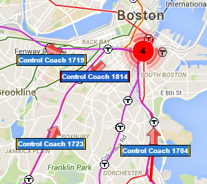
As part of the MassDOT Open Data Initiative, the MBTA publishes real-time GPS transit data for use by third-party developers. Stefan has developed two popular web applications which track and display MBTA Subway and Commuter Rail trains live via Google Maps.
In this talk Stefan will present an overview of the Google Maps Javascript API and the many different MBTA data feeds, plus discuss some of the pain points of developing a web map application that consumes live data. Stefan will demonstrate his own real-time train mapping applications and some other MassDOT and third-party web applications that provide visualization of transit data.
This talk should be of interest to anyone who rides the T, even if you don’t have a background in GIS & mapping.
Speaker Bio:
In his 18 years at Harvard, Stefan has held many different IT positions including IT Security, Research Computing, Data Protection / Disaster Recovery, and UNIX Systems Infrastructure. Currently he is an Implementation Engineer in the HUIT Cloud DevOps group. Stefan has been a volunteer member of the MBTA Rider Oversight Committee since 2005 (mbtaroc.com) and he is known for making terrible puns.
View the presentation slides and video.
no links
Files:
wuensch_image.png