Presented by Dimitris Ballas, a Senior Lecturer in the Department of Geography at the University of Sheffield. October 1st, Noon - 1:30. Room S050, CGIS South building.
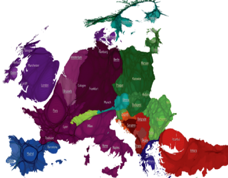
Abstract: Many of us think of European countries as discreet entities: their own languages, cultures, food, and economies squarely contained within their national boundaries. But in fact Europe is at once a unified place and a sophisticatedly fragmented one, and national boundaries rarely reflect its social and economic realities. The social atlas of Europe (www.europemapper.org) is the first atlas to map Europe according to these realities, from the perspective of human geography rather than simply a political one. Using innovative full-colour visualization methods, it reconsiders European identity through its many different facets: economy, culture, history, and human and physical geography, visualizing Europe and its people in a more fluid way, in some cases using maps without artificial national boundaries. This talk will provide an overview of the social atlas of Europe project, which utilizes the latest available demographic, social, and economic data through state-of-the-art geographical information systems and new cartography techniques. The talk will provide an overview of the key methodological approaches that are adopted in this ongoing project (including geovisualisation and spatial microsimulation techniques) and will also illustrate how these are being employed to offer fresh geographical perspectives on a range of topics, including social values, culture, education, employment, environmental footprints, health and well-being, and social inequalities and cohesion.
Speaker: Dimitris Ballas is a Senior Lecturer in the Department of Geography at the University of Sheffield and Deputy Director of the University of Sheffield research Centre for Health and Well-being in Public Policy (CWiPP). He is an economist by training (1996, University of Macedonia, Thessaloniki, Greece) and also has a Master of Arts (with distinction) in Geographical Information Systems (1997, University of Leeds, UK) and a PhD in Geography (2001, University of Leeds, UK). He has significant experience and expertise in social and economic geography and in the use of Geonformatics and GIS in the Social Sciences. His current research interests include European identity and the political economy of the European Union, social and spatial inequalities, social justice, exploring geographies of happiness and well-being and socio-economic applications of GIS. He has published widely in the field of Geoinformatics in the Social Sciences and his most recent work includes The Social Atlas of Europe co-authored with Danny Dorling and Benjamin Hennig (Policy Press, Bristol, 2014; www.europemapper.org).
Presentation Slide: Download (PDF)
no links