July 2016

CGA Newsletter July 2016 PDF (Download)


CGA NEWS

Cartography Tutorial with QGIS 2.14

A quick introduction to making clean and simple maps for publications using QGIS created by Lex Berman of the CGA. The tutorial makes use of historical data found in the China Historical GIS 1820 datasets. View the tutorial.

UAV Remote Sensing Applications Workshop Report

The CGA’s Dave Strohschein recently attended the UAV Remote Sensing Applications (6th Edition) workshop in Barcelona, Spain. Read his full workshop report here.

GIS Site License Software Upgrade (For Harvard Affiliates Only)


CGA’s Monthly GIS Presentations-come join the discussion

  • ABCD-GIS Presentation Series
    Pesenteation (topic to be announced) by Dr. Guoping Huang, Associate Professor at the University of Virginia. July 28th, 2016, 12:00-1:00pm. Room S050, CGIS South Building, 1730 Cambridge St, Cambridge, MA.
  • GIS Colloquium
    Next presentation coming Fall of 2016


CONFERENCES, CALLS, EVENTS & EMPLOYMENT

GIS Research Associate Positions

The Computational Sciences and Engineering Division (CSED) at Oak Ridge National Laboratory (ORNL) is looking for Post Bachelor and Post Master Research Associates with the Geographic Information Science and Technology (GIST) Group. The Associate will support spatial research initiatives with special emphasis in remote sensing and imagery analysis techniques to support population modeling. Read more


Call for Papers: AAG 2017

The Association of American Geographers is holding it’s annual conference in Boston April 5-9 of 2017, and has issued a Call for Papers and Organized Sessions. The submission period is August 1, - October 27, 2016. Read more, and submit a paper.


The CGA Newsletter is published monthly. Editor of this issue: Jeff Blossom.

CGA Home Page . Contact us . Follow us on Twitter

no links

no file attachments

Share

3D Interoperability with ArcGIS, SketchUp, and CityEngine

Presentation by Dr. Guoping Huang  

Thursday, July 28, 2016 - 12:00pm to 1:30pm

     Slides for this talk:  download in PDF

Abstract: 3D GIS data is quickly becoming popular. Drones and LiDAR scanners are widespread. Virtual Reality and Augmented Reality devices are everywhere. GIS users looking to embrace this trajectory are equipped with different programs. Each program caters some specific 3D applications very well. However, working across different programs is still not as straightforward as a user would expect.

In this talk, I plan to focus on the technical side of 3D Interoperability across three programs: ArcGIS, SketchUp, and CityEngine. Examples from my Richmond riverfront viewshed project and Virtual Lhasa project will show the benefits of working with different programs. 

Speaker Bio: Dr. Guoping Huang is an assistant professor of urban and environmental planning in the School of Architecture at University of Virginia. His research interests include digital visualization, geodesign and scenario-based environmental planning. He holds Doctor of Design from Harvard Graduate School of Design and M.S. in landscape planning from Peking University, China.

Lunch will be served.

no links

Files:
guoping_3d.png

Share

Trip Report - UAV Remote Sensing Applications, Edition 6

Workshop report by Dave Strohschein

From June 13th to the 17th, I attended the “UAV Remote Sensing Applications (6th Edition)” workshop. The week long workshop was held in Moia, Spain, about an hour north of Barcelona. The event was presented by the BCN Drone Center and held at their office and test range. The Center is constructed into the side of a small ridge that lies at the center of a 2500 ha of segregated airspace that reaches to 4000 feet above sea level. The Drone Center runs almost completely on electricity generated from roof-top solar panels and a small (4 ft diameter) wind turbine. Additionally, water is collected from a bio-integrated collection system integrated into the roof. Building the Center into the side of a hill reduces the vertical signature of the structure and allows and unobstructed view for manually – controlled UAV flights. The overall location of the BCN Drone Center was selected after geospatial analysis that considered air space, access, population centers, and local topography.
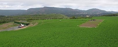
 

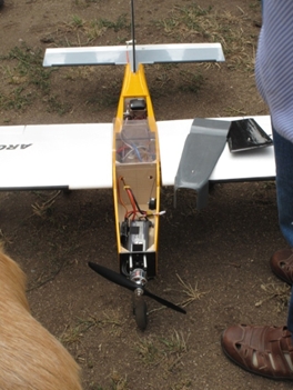
What is now known as the BCN Drone Center was started by Jordi Santacana in 2004. In addition to the runway and segregated airspace, the main building also has a twenty-five seat classroom with individual power outlets, wifi, and digital projection capability. The facility also houses a workshop for building and testing UAVs, a small kitchen, and a small sleeping area. These facilities not only provide an excellent learning environment, but they also provide the resources for testing UAV designs over an extended period of time.
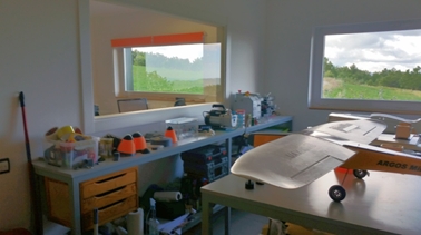



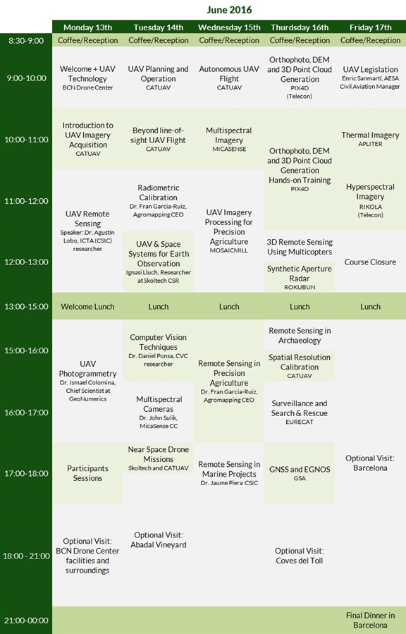
The workshop covered a wide range of topics, as indicated in the complete schedule (I have downloaded the presentations, if anyone is interested). Each day usually began with a presentation or class that provided the background or preparatory material in support of a following live demonstration flight, usually a fixed-wing or quadcopter UAV with an attached camera or sensor. The demonstrations took place immediately outside the BCN Drone Center or a few meters away at the UAV runway.
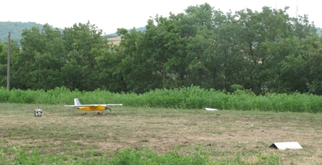
Then we were back in the classroom for an hour or two more of presentations. This was followed by a two-hour lunch break. (The Center is about 2km down a dirt road from town. So, we had a twenty minute ride to get to and from the restaurant at the hotel.) After lunch, we finished the day with two or three more presentations in the classroom.

The presentations were given by individuals from academia and industry. Topics ranged from fundamentals of photogrammetry and remote sensing, radiometric calibration of sensors, flight and mission planning, to presentations and demonstrations with multi-spectral and thermal cameras. In addition to the live demonstration of various UAVs and the integration of various sensors, we installed mission planning and image processing software on our personal computers. A collection of imagery files, collected across the spectrum from UAVs at the Center, were then distributed for our use both during and after the workshop (this data is available, if people are interested).
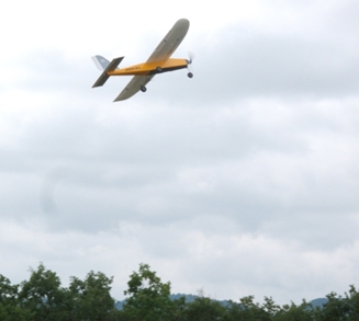
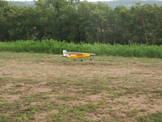
At the start of the workshop, my UAV experience was limited to flying quadcopters: the Phantom DJI-3 and the 3DR Solo. However, after a few of the demonstrations, I began to appreciate the benefits (and difficulty) of flying and managing sensor missions with fixed-wing UAVs. While there is considerable chatter about quadcopters in the U.S., I realized that not all missions are best addressed with rotorcraft. Depending on the task and the mission profile (including time aloft, payload weight, and vibration), fixed-wing aircraft may be the appropriate vehicle for data collection.
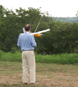
Another interesting bit of information about flying small UAVs in Spain is the ability to [legally] fly them beyond line of sight or autonomous mode. The Spanish UAV industry is more regulated [than the U.S.] to address this additional privilege; pilots must pass an operator certification course to fly. There are three types of certifications. Beginning with the easiest and increasing in difficulty, they are as follows:

  1. Multirotor
  2. Fixed-Wing
  3. Helicopter

Given the additional training time required to operate a fixed-wing UAV manually versus a multirotor UAV, the Center addresses this need by offers the following course: Fixed-Wing Drones Operation and Design.

Hmmmmm…looks like I might just have to return next year…
no links

no file attachments

Share

Introduction to GIS for the GSAS Summer Research Interns

Introduction to GIS workshop.

Download workshop materials.

no links

no file attachments
Share

June 2016

CGA Newsletter June 2016 PDF Download

HIGHLIGHTS

  • Last Call for Registration: Dynamic Mapping of Secondary Cities Workshop
  • The NSF Spatiotemporal Hybrid Cloud Service
  • GIS Site License Software Upgrade (For Harvard Affiliates Only)
  • CGA’s Monthly GIS Presentations
  • Esri UC 2016
  • Call for Papers: CyberGIS’16
  • Global Merchant Fleet Map
  • The Uprooted
  • US Commuter Map
  • More…

CGA NEWS

Last Call for Registration: Dynamic Mapping of Secondary Cities Workshop

A 1.5-day workshop is scheduled for the Mapping Secondary Cities for Resiliency, Human Security, and Emergency Preparedness project sponsored by the NGA and State Department. The project is managed by CGA visiting scholar Dr. Melinda Laituri, who is working with the team to plan an international workshop at Harvard on June 14-15 this year. This day and half workshop will focus on open source geospatial tools and technologies for mapping Secondary Cities. The aim of the workshop is to bring together organizations and individuals involved in innovative mapping activities and solutions for emergency preparedness, resiliency planning, and urban sustainability. Secondary Cities are rapidly growing urban areas that are regional hubs for commerce, services, and governance in developing countries that are often inadequately planned for future development and growth. The workshop will open with a half-day session to provide a hands-on venue to explore and assess online, open sources tools for mapping and creating geospatial date for cities. The full day sessions will include: 1) Secondary Cities overview; 2) Case studies of dynamic city data collection; 3) Interactive assessment session of tools as linked to emergency preparedness, resiliency planning, and urban sustainability; 4) Solutions/Lessons learned. See more information and register (for free) here.

The NSF Spatiotemporal Hybrid Cloud Service

The Spatiotemporal Hybrid Cloud Service (SHCS) is a hybrid cloud computing environment built from multiple cloud systems including OpenStack, Eucalyptus, and Amazon Web Services. The facility is built and operated by the NSF SpatioTemporal Innovation Center. To use the service, please apply here.

GIS Site License Software Upgrade (For Harvard Affiliates Only)

CGA’s Monthly GIS Presentations-come join the discussion

  • ABCD-GIS Presentation Series
    “Geospatial feature level search: The full life cycle from extraction to heat map creation”, presented by Jude Ntabathia, Senior Geospatial Developer at the CGA. June 23rd, 2016, 12:00-1:00pm. Room S050, CGIS South Building, 1730 Cambridge St, Cambridge, MA.
  • GIS Colloquium
    Next presentation coming Fall of 2016

Esri UC 2016

Fei Carnes of the CGA will be in attendance at the Esri User Conference happening June 27- July 1 in San Diego to learn about new trends and emerging technologies in the field of GIS. Harvard GIS users are encouraged to submit questions (if any) through this web form regarding Esri products to be shared with their developers at the conference.

CONFERENCES, CALLS, EVENTS & EMPLOYMENT

Call for Papers: CyberGIS’16

The Third International Conference on CyberGIS and Geospatial Data Science will take place July 26 - 28, 2016 in Urbana, IL, USA. CyberGIS’16 will include an international research symposium that will bring together foremost researchers, practitioners, and educators to share their expertise and knowledge in cyberGIS, geospatial data science, and related fields. The submission deadline is June 10, 2016 at 11:59pm CDT. Read more

The CGA Newsletter is published monthly. Editors of this issue are Fei Carnes and Jeff Blossom.

no links

no file attachments
Share

Geospatial feature level search - The full life cycle from extraction to heat map creation

By Jude Ntabathia

Thursday, June 23 at Noon.  Room S050, CGIS South Building.

View a recording of the presentation.

Abstract: Geospatial search has come a long way. The ability to discover layers as well as metadata on a layers’ features provides a better model for geospatial content discovery. In this talk, I will highlight the process and the model used in extracting feature level data for search and geospatial content discovery. I will conclude by speaking on time based data extraction and the movement towards spatial-temporal search.

Bio:  Jude is a Senior Geospatial Developer with the Center for Geographic Analysis, and has worked as a software developer for the past five years. He is a graduate from the MIT Media Lab under the Centre for Civic Media research group in 2015. He is an avid lover of open source and is interested in studying online communities.

no links

Files:
jude.png

Share

Linked Places - Modeling Historical Movement

The Linked Places Project provides both a conceptual model and practical schema for “historical movement.”   Building upon, and funded by a resource commons grant from Pelagios, (the Linked Open Data platform for historical places and historical collections), the Linked Places project seeks to define the fundemental entities and relationships for historical routes, journeys, itineraries, and flows of goods.

In practical terms, the Linked Places model will be able to capture information about specific journeys, the stopping points along the journey, and enable both mapping, linking references, and more detailed types of geospatial or semantic analysis.

This project springs from earlier work on ORBIS, a geospatial network of the Roman World, with the new objective of creating a simplified, generic, and open resource for describing and linking historical movements through time and space.

Researchers:

Karl Grossner   
Principal Investigator, Linked Places: Modeling Historical Movement
PhD Geography, UC Santa Barbara

Rainer Simon   – download:  PDF of Presentation 
Senior Scientist at the Next-Generation Content Management Systems
AIT Austrian Inst of Technology

Lex Berman
Developer, Temporal Gazetteer  TGAZ
Web Services Manager, CGA

Links:
Codebase
Project Report

Files:
lp-features_01.jpg

Share

10 Years of Business and Mapping

The Harvard Business School’s Baker Research Services and Center for Geographic Analysis share a strong cross center collaboration.   This relationship was initiated by Sarah Ericksen, who reached out to CGA for mapping services nearly 10 years ago. 

This map showcases a few of the numerous mapping projects performed for various HBS faculty resulting from this BRS/CGA kinship, and is meant to serve as a commemorative tribute to Sarah, who is retiring in June of 2016. Scroll down to view locations and map samples that are the fruit of this relationship. 

Links:
10 Years of Business and Mapping

Files:
spiral.png

Share

Enabling Geographic Research Across Disciplines - Building an Institutional Infrastructure for Geographic Analysis at Harvard University

Founded in 1818, the Harvard Map Collection (HMC) is the oldest map collection in America, holding 400,000 maps, more than 6,000 atlases and thousands of reference books. HMC has a strong commitment to digital resources and manages the Harvard Geospatial Library, a foundation for geospatial data service at Harvard. The Center for Geographic Analysis at Harvard University (CGA) was founded in 2006, independent of the library system, to serve the entire university. This article presents the history, organizational structure, and operational model of CGA and HMC, reviews achievements, lessons learned, suggests future improvements, and reviews GIS-related medical research at Harvard.

Links:
Download PDF

no file attachments

Share

Guest Lecture for ECON 2325

Provided guest lecture “Introduction to the CGA, GIS, and some available datasets for mapping“.

no links

no file attachments

Share