Mapping Vegetation with Synthetic Aperture Radar - Applications in Kenya and Southeast Asia

by Thomas Ballatore. 

Noon - 1:30pm on Wednesday, December 7th, 2016.  Room K450, CGIS Knafel building, 1737 Cambridge St., Cambridge, MA.

Slides | Presentation recording

Abstract: Accurate information on the extent and condition of agricultural crops is critical to the formulation and monitoring of food security policies. Remote sensing offers decision makers the ability to look “wide and often”, yet in many areas, persistent cloud cover during the growing season reduces the utility of traditional optical remote sensing techniques. This talk presents recent work on the use of Synthetic Aperture Radar (SAR) to map changes in floodplain vegetation in the Tana River Basin in Kenya as well as rice paddy cultivation in Southeast Asia. The increased availability of free and/or low cost images and processing software is finally putting SAR technology “on the radar” of researchers and decision makers around the world.

Speaker bio: Thomas is the director of the Lake Basin Action Network and a faculty aide at the Center for Geographic Analysis. He has an M.S. in Environmental Engineering from the University of Illinois and a Ph.D. in Urban Engineering from the University of Tokyo. His work focuses on spatial analysis and remote sensing for environmental management in developing countries.

no links

Files:
sar_image_ballatore.jpg

Share

2017 CGA Conference - The Drone Revolution in Spatial Analysis

Conference Program (PDF)    See Videos Linked Below

Unarmed Aerial Systems (UAS), Unmanned Aerial Vehicles (UAVs), or simply “Drones”, represent a new type of remote sensing platform which is inexpensive, easy to use, and provides users with many new options regarding where, when, and how geospatial imagery and data is collected. As the technology proliferates, it is revolutionizing both spatial data collection and geographic analysis. This paradigm shift brings new perspectives to a wide range of application fields, and calls for new skills, best practices, regulations, policies, ethics, and more.

This conference aims at illuminating the profound changes drones have brought to mapping practice, from platform and sensor selection, flight path planning, field operations, data processing, image analysis, feature extraction, 3-D model construction, and visualization. Experts will share their experiences with application cases and first-hand operational logistics.

The event will start with a half-day hands-on demo and training workshop Thursday afternoon, followed by a full day of plenary sessions on Friday, which will include a keynote address, presentation sessions, panel discussions, and closing remarks. Invited speakers will engage with the audience in discussions on the current status, achievements, lessons learned, unmet needs, challenges, potentials, and perspectives of drones in spatial data collection and analysis, particularly as it relates to academic research and learning.

The event is free and open to the public. Please register using the button above.

Rooms: Belfer Case Study Room (Thursday, April 27) and Tsai Auditorium (Friday, April 28)
Location: CGIS South Building, 1730 Cambridge St., Cambridge, MA 02138

SPONSORS Include:

BCN Drone Center, Moià, Barcelona, Spain ESRI

—-

Conference Videos:

Day 1 April 27, 2017

 Welcome & Orientation - Jason Ur  VIDEO

 Drone imagery in ArcGIS (Esri)Cody Benkelman  VIDEO

 OpenDroneMap - Free and Open Source Toolkit for Creating Aerial Orthomosaics (MIT Urban Risk Lab)Tomas Holderness  VIDEO

 Drone applications at the Harvard Humanitarian InitiativeFaine Greenwood  VIDEO


Day 2  April 28, 2017

 Session 1 - Ethnics and Legal Issues

   Universities and the New FAA Regulations, Matthew Fox  VIDEO

   Eye in the Sky - Ethical Issues and Humanitarian Drones, Faine Greenwood  VIDEO

   Place-based relationships linking drone warfare and agricultural land cover and livelihood

   dynamics in northwest Pakistan, Jamon Van Den Hoek  VIDEO

   Drones and Federal Preemption: Who Controls the Airspace over Your Backyard, Kevin Pomfret VIDEO

   Implementing UAS for Scientific Research in the Department of the Interior, Jeff Sloan  VIDEO

   Ethics and Legal Issues: Panel Discussion  VIDEO


 Session 2 - Hardware: Platforms and Sensors

   Low Cost Drones and Archaeology: Evolving Method, Austin (Chad) HillVIDEO

   Drones for Spatial Storytelling, Ben KriemerVIDEO

   DJI and Automating Drone Missions, Brandon MontelattoVIDEO

   Balloons and Kites in the Age of Autonomous Flight,  Jeffrey WarrenVIDEO

   Hardware: platforms and sensors, Panel Discussion  VIDEO


 Keynote Presentation

   Drones for Resilience, Jarlath O’Neil-DunneVIDEO


  Session 3 - Software: Data Processing and Analysis

   Drone Air Photography and 3D Modeling in Archaeology, Luis Jaime CastilloVIDEO

   UAS Hyperspectral Data Processing and Analysis, Donna DelparteVIDEO

   Workflow and data optimization using Structure from Motion, Robert HomsherVIDEO

   The Illusion of Simplicity and the Arrival of Disappearance, Lawrie JordanVIDEO

   Automation of aerial mapping with small drones, Walter VolkmannVIDEO

   Software: data processing and analysis, Panel DiscussionVIDEO


  Session 4 - Applications Across Disciplines

   Enabling Research: Data Collectoin with UAS, Daniel Sheehan and Mike FosterVIDEO

   Drone-based Sensing in Amazonia, Scot MartinVIDEO

   Drones in Marine Science, Everette NewtonVIDEO

   Issues with Humanitarian Use of Drones, Nathaniel RaymondVIDEO

   Drones and Historical Landscapes, Jason UrVIDEO

   Applications Across Disciplines, Panel DiscussionVIDEO


  Closing Remarks and Awards.  Faine Greenwood, Alexandra Vacroux, Jason UrVIDEO

no links

no file attachments

Share

Esri Demographic Data for Education 2016

The following data (size: 20GB) is available in the HMDC computer lab in CGIS Knafel K026 (T:\Esri_Data_2016). It may be copied to a local or network hard drive, used in the lab, or mapped using the path \fas-depts.ad.fas.harvard.edu\cgis\arcgis (it requires the fas_domain account login).

  • Esri 2016 -2021 Updated Demographics
  • Esri 2016 Tapestry
  • Esri 2016 Consumer Spending
  • 2010 Census (Updated 2016)
  • 2010 -2014 American Community Survey

The data is for educational use only, and is presented in file geodatabase format at all levels of geography (state, county, census tract, block group, place, and ZIP code), for the entire U.S., and can be used in ArcGIS for Desktop, ArcGIS for Server, or other display/analysis software. read more

no links

no file attachments

Share

Status of WorldMap, 2016

Download PDF

An overview of WorldMap development, system architecture and recently added functions, such as HHypermap Search of WMS layers.

no links

no file attachments

Share

The Northern Sea Route Map

A map depicting the Northern Sea route boundary and ports in the Arctic was published in Arctic Yearbook 2016.

no links

Files:
2016-11-01_1539.png

Share

September 2016

CGA Newsletter September 2016 PDF Download

CGA NEWS

Upcoming GIS Technical Training Workshops

CGA offers several non-credit technical training workshops related to GIS (Free to Harvard affiliates but registration is required). The workshops for September are:

  • Basic Introduction to GIS - Cambridge, by Jeff Blossom, 1:30-3:30pm, September 9th, 2016
  • Wrangling Data into Maps - Cambridge, by Jeff Blossom, 1:30-3:30pm, September 16th, 2016
  • Making Sense out of Spatial Data - Cambridge, by Wendy Guan, 1:30-3:30pm, September 23rd, 2016
  • Open Source QGIS 2.0, by Merrick Lex Berman, 1:30-3:30pm, September 30th, 2016
  • ArcGIS Online & ArcGIS Maps for Office, by Giovanni Zambotti, 1:30-3:30pm, October 7th, 2016
  • Exploring Google’s Mapping Products, by Jeff Blossom, 1:30-3:30pm, October 14th, 2016

More information about all technical training workshops and registrations can be found here.

CGA’s Monthly GIS Presentations-come join the discussion

  • ABCD-GIS Presentation Series
    “Research Frontiers in Analysing Social Media Data”, by Bernd Resch, Assistant Professor at University of Salzburg’s Department of Geoinformatics. Thursday, September 22nd, 2016, 12:00-1:30pm. Room S354, CGIS South Building, 1730 Cambridge St, Cambridge, MA.
  • GIS Colloquium
    “Seeking Space and Place in Holocaust Testimony” by Anne Knowles, Professor of History at the University of Maine. Friday, October 7th, 2016, 12:00-1:30pm. Room 107, Robinson Hall (Harvard Yard), Cambridge, MA.
 

GIS Institute Application Deadline October 21st

This two-week program of intensive training in geographic information systems (GIS) will next be offered in January of 2017. Click here for more information and here to register.


Esri’s New Training Website

Esri’s new e-learning site includes self-paced courses, seminars, videos, and other resources covering a wide variety of GIS and ArcGIS topics. Harvard affiliates have unlimited access to these sources. Click here for more information.


CONFERENCES, CALLS, EVENTS & EMPLOYMENT

Post Doctoral Position at NC State Center for Geospatial Analytics

The Center for Geospatial Analytics at NC State invites applications for an innovative and highly motivated Postdoctoral Scientist to join its Landscape Dynamics Group, led by Ross K. Meentemeyer. Review of applications will begin September 19, 2016 and continue until the position is filled. Read more

Part Time GIS Position with the City of Cambridge

The City of Cambridge is looking for a part-time GIS Technician. A major theme of this position is the use of 3D within GIS. Read more

Travel Funding Available for the 2017 ICA in Washington, DC

The U.S. National Committee (USNC) to the International Cartographic Association (ICA) is pleased to announce the availability of travel funding to attend the 28th International Cartographic Conference (ICC) in Washington, DC, July 2-7, 2017. The deadline for applications is October 26. Read more

The CGA Newsletter is published monthly. Editors of this issue: Fei Carnes, and Jeff Blossom.

This newsletter passes on news items and information about new web maps or uses of GIS that come to the CGA’s attention from various sources. These are provided for informational purposes only. The CGA does not endorse these items and makes no representations about their accuracy, completeness or quality. © Present & Fellows Harvard University. All Rights Reserved.


no links

no file attachments

Share

October 2016

CGA Newsletter October 2016 PDF Download

CGA NEWS

GIS Institute Call for Applications: Deadline October 21st

This two-week program of intensive training in geographic information systems (GIS) will next be offered in January of 2017. Click here for more information and here to register.


Open Position at CGA: GIS Specialist

The CGA is currently seeking a GIS Specialist. Application deadline is October 31, 2016. For more information and to apply, click here.


Upcoming GIS Technical Training Workshops

CGA offers several non-credit technical training workshops related to GIS (Free to Harvard affiliates but registration is required). The workshops are:

  • Exploring Google’s Mapping Products, by Jeff Blossom, 1:30-3:30pm, October 14th, 2016
  • Worldmap Introduction, by Ben Lewis, 1:30-3:30pm, October 21st, 2016
  • Introduction to Remote Sensing, by Fei Carnes, 1:30-3:30pm, October 28th, 2016
  • Wrangling Data into Maps - Longwood, by Jeff Blossom, 1:30-3:30pm, October 28th, 2016
  • Geoprocessing with ModelBuilder, by Giovanni Zambotti, 1:30-3:30pm, November 4th, 2016
  • Making Sense out of Spatial Data - Longwood, by Jeff Blossom, 1:30-3:30pm, November 4th, 2016
  • Three-Dimensional GIS, by Paul Cote, 1:30-3:30pm, November 10th, 2016

More information about all technical training workshops and registrations can be found here.

GIS Site License Software Upgrade (For Harvard Affiliates Only)


CGA’s Monthly GIS Presentations-come join the discussion

  • GIS Colloquium
    “The Relevance of Cartography” by Georg Gartner, Professor of Cartography at the Vienna University of Technology. Thursday, October 13th, 2016, 12:00-1:30pm. Room K401, CGIS Knafel building, 1737 Cambridge St., Cambridge, MA.
  • ABCD-GIS Presentation Series
    “Using CARTO for Geospatial Data Visualization”, by Jeff Ferzoco and Andy Eschbacher from the CARTO. Thursday, November 3rd, 2016, 12:00-1:30pm. Room S154, CGIS South Building, 1730 Cambridge St, Cambridge, MA.
 

Boundless Adopts Harvard Hypermap

The GIS company Boundless has integrated Harvard Hypermap (HHypermap) into their core mapping. Read more


Announcing the 2017 PGSG Preconference at Harvard

The AAG Political Geography Specialty Group is pleased to announce that the 30th Annual Preconference will be held at Harvard University on Tuesday, April 4, 2017, hosted and supported by the Center for Geographic Analysis, the Institute for Quantitative Social Science, and the Department of Government. More details can be found here.


CONFERENCES, CALLS, EVENTS & EMPLOYMENT

The International Year of Global Understanding Story Maps Competition

This contest is inviting high school and college age students to share their perspectives and research on topics associated with global understanding by creating story maps that examine and address the ways in which we inhabit our increasingly globalized world. Read more

GIS Teaching Position at the College of William and Mary

The Center for Geospatial Analysis at the College of William and Mary is recruiting an adjunct teaching position for the Spring 2017 semester. Read more

Esri Conferences Call for Papers

The 2017 Esri UC and the Esri Education GIS Conference are calling for papers. The deadline for both are October 28, 2016.

The CGA Newsletter is published monthly. Editors of this issue: Fei Carnes, and Jeff Blossom.

This newsletter passes on news items and information about new web maps or uses of GIS that come to the CGA’s attention from various sources. These are provided for informational purposes only. The CGA does not endorse these items and makes no representations about their accuracy, completeness or quality. © Present & Fellows Harvard University. All Rights Reserved.


no links

no file attachments

Share

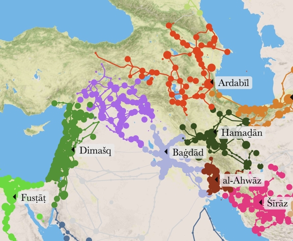
From Text to Map - Arabic Biographical Collections and Geospatial Analysis

Speaker:   Dr. Maxim Romanov     website
Research Fellow, Alexander von Humboldt-Lehrstul für Digital Humanities
Institut für Informatik, Universität Leipzig

Thursday, Nov 17th, Noon - 1:30. Room S-050, CGIS South building, 1730 Cambridge St

Abstract:  Thousands of fully-digitized texts of premodern Arabic sources have become available over the past decade or two. Computational methods of text analysis now offer us a key to the riches of extensive biographical collections. Mapped across time and space, tens of thousands of biographies may give us a novel and multifaceted perspective on Islamic history. The presentation will focus on major steps—moving from text to map—and highlight some results of such computational endeavors.

Speaker Bio:  Maxim Romanov applies modern computational techniques of text analysis to the study of premodern Arabic historical sources.  After completing his PhD (Univ of Michigan) he was post-Doctoral associate with the Perseus Project (Tufts University), and is now working with the Digital Humanities team at Leipzig University on advanced digital analysis methods for Arabic texts, including Arabic Optical Character Recognition.

This talk is co-sponsored by the Harvard Department of Near Eastern Languages and Civilizations, and ShariaSource, the Islamic Legal Studies Program of Harvard Law School.

no links

Files:
2017-01-05_1006.png

Share

Using CARTO for Geospatial Data Visualization

Link to VIDEO Presentation

Presenters:  Jeff Ferzoco and Andy Eschbacher

Room S354, CGIS South, 1730 Cambridge St.

This presentation is a hands on introduction to the online GIS software CARTO. Bring your laptop to follow along!

CARTO (formerly CartoDB) is software that provides GIS and web mapping tools.  The CGA has recently purchased CARTO, and it is available for any Harvard affiliate to use.  For those interested in learning more about CARTO and to practice using it, this workshop will cover: 

  • What CARTO is and how to use it
  • Account creation
  • Basic map creation
  • CARTO Builder location intelligence
  • CARTO Editor

Lunch will be served.

no links

Files:
carto_image.png

Share

The Relevance of Cartography

By Georg Gartner, Full Professor of Cartography at the Vienna University of Technology.

Thursday, 10/13, Noon - 1:30. Room K401, CGIS Knafel building, 1737 Cambridge St.

View presentation recording

Abstract:  Today maps can be created and used by any individual stocked with just modest computing skills from virtually any location on Earth and for almost any purpose. In this new mapmaking paradigm users are often present at the location of interest and produce maps that address needs that arise instantaneously. Cartographic data may be digitally and wirelessly delivered in finalized form to the device in the hands of the user or he may derive the requested visualization from downloaded data in situ. Rapid advances in technologies have enabled this revolution in map making by the millions. One such prominent advance includes the possibility to derive maps very quickly immediately after the data has been acquired by accessing and disseminating maps through the internet. Real-time data handling and visualization are other significant developments as well location-based services, mobile cartography augmented reality.

Thus Cartography is seen by many as facing a change of paradigms currently. This presentation reviews the enormous diversity of fundamental questions which are appearing in modern cartography based on these developments. It argues that a theoretical fundament is necessary to be able to define the core elements of a discipline. The role of international efforts in this respect is discussed and will be highlighted. By discussing current cartographic research projects of the Vienna University of Technology the vision of a contemporary, modern, innovative, attractive domain of Cartography is discussed.

Speaker Bio:

Georg Gartner is a Full Professor for Cartography at the Vienna University of Technology. He holds graduate qualifications in Geography and Cartography from the University of Vienna and received his Ph.D. and his Habilitation from the Vienna University of Technology. He was awarded a Fulbright grant to the USA and several research visiting fellowships. He was Dean for Academic Affairs for Geodesy and Geoinformation at Vienna University of Technology. He is Editor of the Book Series “Lecture Notes on Geoinformation and Cartography” by Springer and Editor of the “Journal on LBS” by Taylor & Francis. He served from 2011 - 2015 as President of the International Cartographic Association.

no links

Files:
modern_carto.png

Share