January 2017

CGA Newsletter January 2017 PDF Download

CGA NEWS

Upcoming GIS Technical Training Workshops

CGA offers several non-credit technical training workshops related to GIS (Free to Harvard affiliates but registration is required). The workshops are:

  • Basic Introduction to GIS - Longwood, by Jeff Blossom, 1:30-3:30pm, January 27th, 2017
  • Basic Introduction to GIS - Cambridge, by Jeff Blossom, 1:30-3:30pm, February 3rd, 2017
  • Wrangling Data into Maps - Cambridge, by Jeff Blossom, 1:30-3:30pm, February 10th, 2017

More information about all technical training workshops and registrations can be found here.

GIS Site License Software Upgrade (For Harvard Affiliates Only)


CGA’s Monthly GIS Presentations-come join the discussion

  • ABCD-GIS Presentation Series
    “An Internet of Things approach to situation awareness for first responders”, presented by Josh Lieberman, senior research scientist at CGA. Thursday, January 19th, 2017, 12:00-1:30pm. Room S354, CGIS South building, 1730 Cambridge St., Cambridge, MA.
  • GIS Colloquium
    Next presentation coming February of 2017
 

Mapping Ten Million Footsteps

Jeff Blossom from the CGA wrote the story - Mapping Ten Million Footsteps, which is part of the National Geographic Out of Eden Walk project. He takes the GPS route of Paul Salopek, who is walking around the world on a “slow journalism” trek, and calculates how many steps have been taken in the many countries along the route. The article also features different cartographic effects using WorldMap. The project turned 4 years old on January 10th. It is funded by the Knight Foundation, National Geographic, and a Kickstarter fundraiser.


Fisher Prize and EDC Award

Submissions are now being accepted for two Harvard student awards for GIS excellence. Click the links below for more information and to apply: Fisher Prize| ESRI Development Center Student of the Year


HARVARD GIS COMMUNITY NEWS

Harvard DataFest 2017

DataFest is a new two-day workshop held during J-term and developed by data practitioners and researchers from across the university. Hosted by the Institute for Quantitative Social Science (IQSS), the purpose of the workshop is for participants to develop skills in working with data. The workshop is open to Harvard affiliates only. Read more and register


Job opening - Research Assistant on Transportation and Land Use Issues in China with Harvard China Project

A student Research Assistant with an interest in transportation and land use issues in China is needed for a study using household survey data from a travel behavior study conducted in Chengdu. The position is open to graduate students of any relevant department or school of Harvard University. Harvard undergraduate students with exceptional skills may also be considered. Read more

CONFERENCES, CALLS & EVENTS

Call for Abstract - 2nd International Symposium on Spatiotemporal Computing at Harvard

The 2nd International Symposium on Spatiotemporal Computing will be held August 7-9, 2017 at Harvard University. The deadline to submit an abstract is February 28th. Please click here for submission guidelines, and click here for more details on the Symposium.


NEGIS Scholarship 2017

The Northeast Geographic Information Society (NEGIS) is offering a scholarship and internship opportunity for GIS students attending New England-area colleges, universities and technical institutes. Information regarding the scholarship and the application form can be accessed here. The deadline for applications is Monday, January 16, 2017.

Esri MOOC

Esri is offering two MOOCs in the coming February. One is Earth Image at Work, and the other is Do-It-Yourself Geo Apps.

The CGA Newsletter is published monthly. Editors of this issue: Fei Carnes, and Jeff Blossom.

CGA Home Page . Contact us . Follow us on Twitter

This newsletter passes on news items and information about new web maps or uses of GIS that come to the CGA’s attention from various sources. These are provided for informational purposes only. The CGA does not endorse these items and makes no representations about their accuracy, completeness or quality. © Present & Fellows Harvard University. All Rights Reserved.


no links

no file attachments

Share

November 2016

CGA Newsletter November 2016 PDF Download

CGA NEWS

Senior Geospatial Developer at Harvard CGA

The CGA is currently seeking a Senior Geospatial Developer. Application deadline is November 16, 2016. For more information and to apply, click here.


Upcoming GIS Technical Training Workshops

CGA offers several non-credit technical training workshops related to GIS (Free to Harvard affiliates but registration is required). The workshops are:

  • GPS Data Collection, by Jeff Blossom, 1:30-4:30pm, November 18th, 2016
  • Database Design for GPS/GIS Applications, by Nicole Alexander, 1:30-3:30pm, December 2nd, 2016

More information about all technical training workshops and registrations can be found here.

GIS Site License Software Upgrade (For Harvard Affiliates Only)


CGA’s Monthly GIS Presentations-come join the discussion

  • GIS Colloquium
    “From Text to Map: Arabic Biographical Collections and Geospatial Analysis”, presented by Maxim Romanov, Research Fellow in the Digital Humanities team at Leipzig University. Thursday, November 17th, 2016, 12:00-1:30pm. Room S050, CGIS South building, 1730 Cambridge St., Cambridge, MA.
  • ABCD-GIS Presentation Series
    Presentation (topic to be announced) by Thomas Ballatore, the director of the Lake Basin Action Network and a faculty aide at the CGA. Wednesday, December 7th, 2016, 12:00-1:30pm. Room K450, CGIS Knafel building, 1737 Cambridge St., Cambridge, MA.
 

HARVARD GIS COMMUNITY NEWS

2015 LandScan Data Available from the Map Collection

The Harvard Map Collection has received the 2015 LandScan global population raster dataset. The data can be downloaded from here. The LandScan 2000- 2014 datasets can be accessed using the same link form but change the year.

CONFERENCES, CALLS, EVENTS & EMPLOYMENT

The Fifth Annual Graduate History Association Conference

The Graduate History Association at Washington University in St. Louis invites graduate and post-doctoral students engaged in research across disciplines to submit proposals for this year’s conference theme: The Spatial Turn. The Conference will explore questions pertaining to the social, political, economic and cultural relations between people and landscapes. Read more

The CGA Newsletter is published monthly. Editors of this issue: Fei Carnes, and Ben Lewis.

This newsletter passes on news items and information about new web maps or uses of GIS that come to the CGA’s attention from various sources. These are provided for informational purposes only. The CGA does not endorse these items and makes no representations about their accuracy, completeness or quality. © Present & Fellows Harvard University. All Rights Reserved.

no links

no file attachments

Share

December 2016

CGA Newsletter December 2016 PDF Download

CGA NEWS

CGA’s Monthly GIS Presentations-come join the discussion

  • ABCD-GIS Presentation Series
    “An Internet of Things approach to situation awareness for first responders”, presented by Josh Lieberman, senior research scientist at CGA. Thursday, January 19th, 2017, 12:00-1:30pm. Room S354, CGIS South building, 1730 Cambridge St., Cambridge, MA.
  • GIS Colloquium
    Next presentation coming February of 2017

Exploring the World of Connectography Interactive Map

Jeff Blossom from the CGA collaborated with Parag Khanna to build this interactive map on the global infrastructure networks depicted in Parag Khanna’s 2016 book Connectography - Mapping the Future of Global Civilization.

HARVARD GIS COMMUNITY NEWS

Harvard DataFest 2017

DataFest is a new two-day workshop held during J-term and developed by data practitioners and researchers from across the university. Hosted by the Institute for Quantitative Social Science (IQSS), the purpose of the workshop is for participants to develop skills in working with data. The workshop is open to Harvard affiliates only. Read more and to register


Infogroup US Historical Business Data 1997-2014

The InfoGroup’s historical business data consists of geocoded records of US businesses and other organizations that contain basic information on each entity, including contact information, industry description, annual revenues, number of employees, year established, and other data. Each annual file consists of a “snapshot” of InfoGroup’s data as of the last day of each year, creating a time series of data 1997-2014. Each data file is available in either .csv or .sas format. Access is restricted to current Harvard affiliates.

CONFERENCES, CALLS, EVENTS & EMPLOYMENT

Public Health Data Analyst with Johns Hopkins

Johns Hopkins Bloomberg School of Public Health is looking for a data analyst who is familiar with R and ArcGIS. This position will perform data management, data analysis and spatial data management and analysis for several epidemiology and public health research studies. Read more

The CGA Newsletter is published monthly. Editors of this issue: Fei Carnes, and Jeff Blossom.

This newsletter passes on news items and information about new web maps or uses of GIS that come to the CGA’s attention from various sources. These are provided for informational purposes only. The CGA does not endorse these items and makes no representations about their accuracy, completeness or quality. © Present & Fellows Harvard University. All Rights Reserved.

no links

no file attachments

Share

Indian Air Pollution Data

[cga contact: Lex Berman]

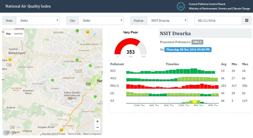
With the recent decision by the Indian Goverment (announced in April 2015) to publish hourly Air Quality Index [AQI] monitoring data, CGA has begun to investigate how we might systematically collect, archive, and analyze this information.

With technical documentation provided on the Indian Ministry of Environment Central Pollution Control Board website ( http://www.cpcb.nic.in/air.php ), we found suitable details about the monitoring equipment and data collection methodology to take a closer look at their data.

IIT Kanpur, the technical unit responsible for making these monitoring observations available, has launched a public website:  http://164.100.160.234:9000/

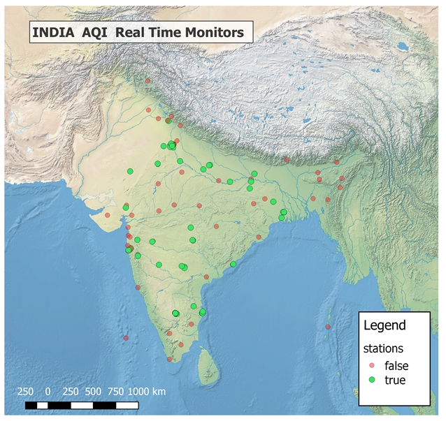
Based on a detailed investigation of this website, CGA team members Lex Berman and Devika Kakkar  have developed a prototype to acquire daily average and hourly readings from the official MOE monitor stations.   Currently there are only about 50 statioins registered in the Pollution Control monitoring network.  These stations are distributed geographically as shown in the following map.

The prototype data collection tool identifies the stations, their locations, then acquires hourly readings for AQI measurements such as PM2.5, So2, No2, CO, O3, and also gets synchronous meterological information from a separate web service.

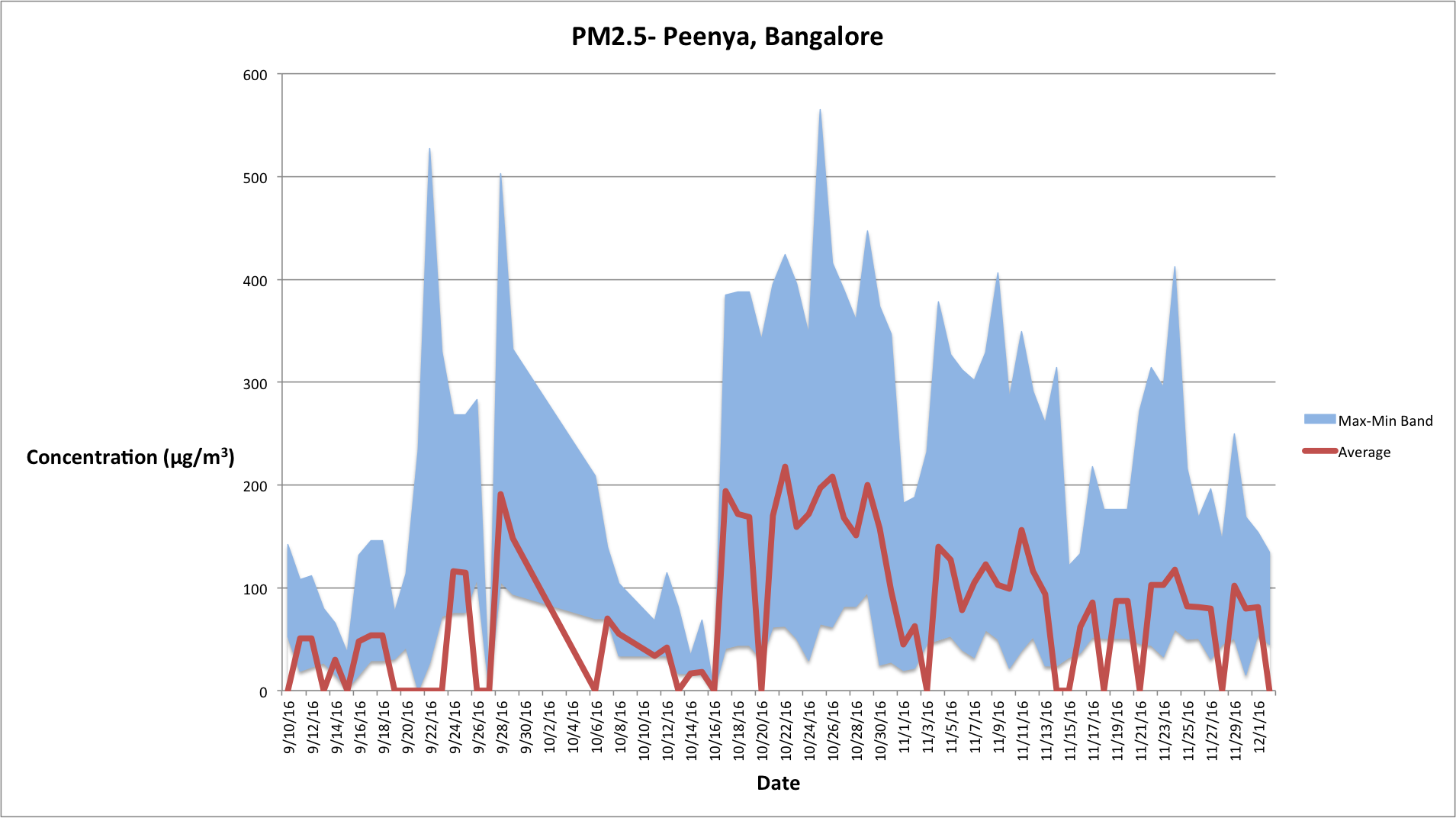
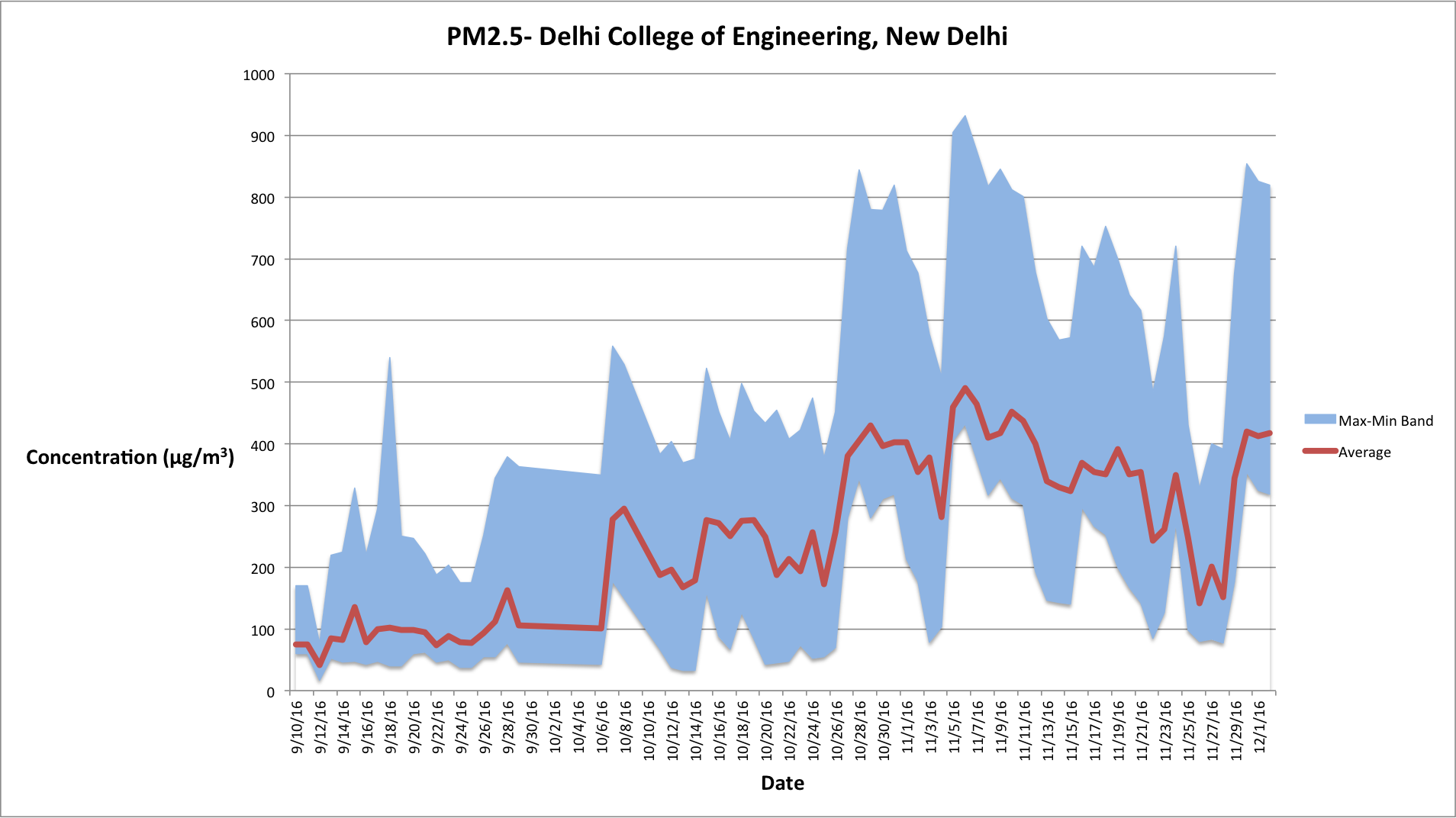
The preliminary testing data can be graphed to show daily activity for PM2.5, for example.


[Note on graphs: the average values which show “0” are not zeros but have values of “-“ or “N/A” in the source files, i.e there are no average values reported for that date.]

CGA is currently seeking collaborators to move this prototype to a production system for continuous acquisition of the Indian Air Pollution data, which can be made available as a public archive for academic research (similar to our China AQI data collection:  http://aqi.cga.harvard.edu/china/about/).


no links

no file attachments

Share

An Internet of Things approach to situation awareness for first responders

By Josh Lieberman, senior research scientist at CGA.  Thursday, 1/19 at Noon in Room S354, CGIS South Building, 1730 Cambridge St.

Video of presentationYoutube

Abstract: Near realtime Information on the context of an emergency situation and its progression is critical to support first responders who put their own safety at risk to keep others safe. Tools to collect and access that information need to be easy and reliable enough to be used in most any environment by non IT specialists, cost effective enough for state and local government budgets, and scalable to any size of incident. Internet of Things principles and standards have been implemented to address these criteria in an Open Geospatial Consortium pilot activity for the Department of Homeland Security. The goal of the Pilot was to assemble many inexpensive off-the-shelf sensors into an ad hoc yet coherent distributed information system available to everyone involved in responding to or coordinating emergency situations. Many of the tools used in this pilot are based on open source hardware and software, lowering the bar for adoption of this approach for this and many other comparable sensor applications.

Speaker Bio: Josh is a senior research scientist at CGA working on hydrographic ontologies and semantic applications for the U.S. National Map as part of the new Spatiotemporal Innovation Center. He also serves as a coordinating architect and initiative manager for the Open Geospatial Consortium and as a lecturer at the University of Maryland Baltimore County. Josh has a Ph.D. from the University of Washington, M.S. from the University of Oregon, and A.B. from Dartmouth College, as well as many years of experience in earth and environmental sciences and geospatial modeling.

Lunch will be served.

no links

Files:
drone.png

Share

Fairbank Center Alumni Mapping

This interactive map visualizes the Fairbank Center alumni across the world.

Links:
Fairbank Center Alumni Mapping

Files:
alumni_orig.png

Share

Linked Spatial Web Data and Ontology Applications in Surface Water Hydrology

By Josh Lieberman, senior research scientist at CGA.

Thursday, December 1, 2016. Noon - 1:30. Room S354, CGIS South building, 1730 Cambridge St.

Abstract: Effective spatial data use on the Web means being able to link disparate data elements such as features and geometry across the Web. Spatial data interoperability across the Web requires both a common model and vocabulary of spatial concepts. The presentation will cover a number of vocabularies developed in RDF/OWL to communicate both general spatial concepts and the specific entities involved in the study and mapping of surface water features in the U.S. and elsewhere. Linked data mechanisms and RDF/OWL ontologies allow such data not only to be “webified” and distributed widely, but also fit well with the multi scale and diverse network representations of hydro features. Tools will be covered that enable transformation of relational hydro data into linked data, publication, mapping, and analysis.

Speaker Bio: Josh is a senior research scientist at CGA working on hydrographic ontologies and semantic applications for the U.S. National Map as part of the new Spatiotemporal Innovation Center. He also serves as a coordinating architect and initiative manager for the Open Geospatial Consortium and as a lecturer at the University of Maryland Baltimore County. Josh has a Ph.D. from the University of Washington, M.S. from the University of Oregon, and A.B. from Dartmouth College, as well as many years of experience in earth and environmental sciences and geospatial modeling.

no links

Files:
pastedgraphic-1.jpg

Share

The Historical Geographic Background of the Silk Road

Speaker:  Ge Jianxiong, Professor of the Institute of Historical Geography, Fudan University, as well as the Librarian of Fudan University.

more information available here

time:   21st November, 5:00pm to 6:30pm

location:  Fong Auditorium, Boylston Hall

Sponsored by the Fairbank Center for Chinese Studies


no links

no file attachments

Share

Introduction to GIS for students in - Integrated Sustainable Design and Planning - from Buildings to Communities

Introduction to GIS lecture and class mapping exercise for students in Harvard Extension School class “Integrated Sustainable Design and Planning: from Buildings to Communities”.

Download the lecture and exercise.

no links

no file attachments

Share

Introduction to GIS for Mixed Methods in Global Health

Providing a lecture on GIS for the “Mixed Methods Research” CM82 course, a distance course taught by HSPH to students at King Abdulaziz university in Jeddah, Saudi Arabia.

Download the presentation slides.

no links

no file attachments

Share