GIS for the Humanities and Social Sciences 2017

Updated Location: Room 203, Harvard DCE computer facility at 53 Church St., Cambridge MA.

Registration Schedule:

  1. Registration deadline:

    Tuesday, 12/05/17 @ 1:00 PM.

  2. $25 Registration fee deadline:

    Friday, 12/08/17 @ 9:00 AM.

  3. Workshop date:

    Friday, 12/08/17 @ 9:00AM

How to Apply:

  • For Harvard Affiliates, please submit your application by clicking the “REGISTER” button (HUID login required).
  • For Non-Harvard applicants, please submit your application by clicking the “NON-HARVARD REGISTER“ button.

Recommended for each participant:

  • Your laptop.  We’ll be in a computer lab, so this is not essential as students can use the lab machines.  But installing and using the GIS software on your own laptop is a good accelerant to using and learning GIS. 
  • If you have a laptop:  Download and install  GoogleEarthPro, and QGIS,  (both free)
  • Create a login on the Worldmap site (http://worldmap.harvard.edu)
  • Bring any data or documents you want to map or work with.  Time permitting, the instructors will look at your data and offer suggestions.

no links

no file attachments

Share

Esri Development Center Student of the Year Award 2017

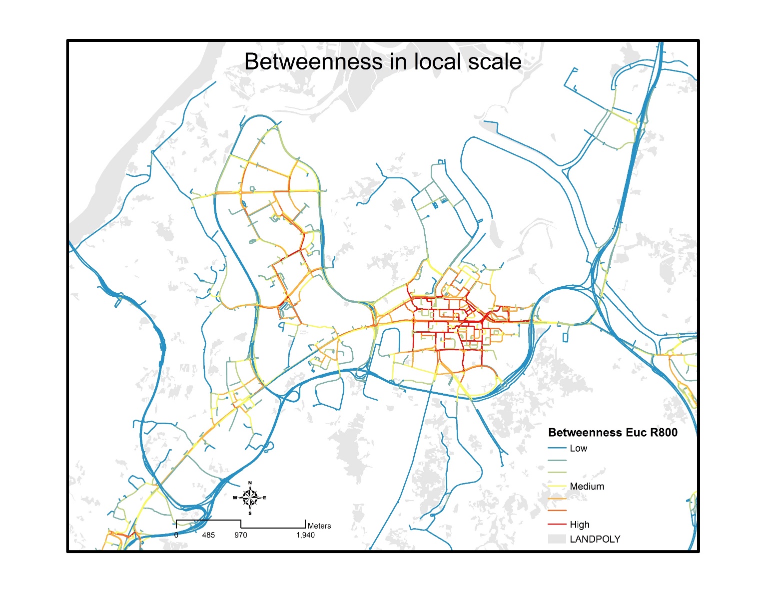
Title: How do pedestrian choose their routes?

View the abstract.  View the poster.

Judges comments:  ”high marks for originality in using Esri components to create a new urban networking tool”

“compelling map and other visualizations”

“innovative methods to model pedestrian flows, successfully sequencing many complex steps to produce a solid model backed by field observations”


no links

Files:
wu2017.png

Share

March 2017

CGA Newsletter March 2017 PDF (Download)


CGA NEWS

ArcGIS Pro Workshop March 31st

ArcGIS Pro is now Esri’s main GIS software platform, and this introductory workshop will help GIS students and professionals get up to speed quickly with ArcGIS Pro terminology and the new, intuitive tools to efficiently complete mapping, editing, geoprocessing, and analysis projects. Students will explore the new interface, practice using 2D and 3D capabilities, and learn how to share GIS content more quickly and easily than ever before. The workshop is March 31st, from 1:30 - 3:30. Register for the Workshop.


Call for Registration - 2017 CGA Conference: The Drone Revolution in Spatial Analysis

This year’s CGA conference aims at illuminating the profound changes drones have brought to mapping practice, from platform and sensor selection, flight path planning, field operations, data processing, image analysis, feature extraction, 3-D model construction, and visualization. Experts will share their experiences with application cases and first-hand operational logistics. The conference preliminary program is available online. To register, please click here.


Upcoming GIS Technical Training Workshops

CGA offers several non-credit technical training workshops related to GIS (Free to Harvard affiliates but registration is required). The workshops are:

  • Getting to Know ArcGIS Network Analyst, by Fei Carnes, 1:30-3:30pm, March 24th, 2017
  • ArcGIS Pro Workshop, by Esri, 1:30-3:30pm, March 31st, 2017
  • Making Sense out of Spatial Data - Longwood, by Giovanni Zambotti, 1:30-3:30pm, March 31st, 2017
  • ArcGIS Online & ArcGIS Maps for Office, by Giovanni Zambotti, April 7th, 2017

More information about all technical training workshops and registrations can be found here.

  • Cartography Workshop, a more intensive full day workshop by Jeff Blossom and Stacy Bogan offered on April 21st, 2017. Click here to register.

CGA’s Monthly GIS Presentations - come join the discussion.

  • ABCD-GIS Presentation Series
    “Billion Object Platform (BOP)- an Open Source, Real-Time, Billion Object Spatio-Temporal Search Platform”, presented by Devika Kakkar and David Smiley. Thursday, March 23rd, 2017. Click here for presentation abstract and speaker bios.
    “ArcGIS Pro and Platform Introduction”, presented by Mark Scott and Tom Schwartzman from Esri. Friday, March 31st. Click here for the talk abstract and speaker bios. 2017, 12:00-1:00pm. Room K450, CGIS Knafel building, 1737 Cambridge St., Cambridge, MA.
  • Geography Colloquium
    The next Geography Colloquium will be April 6th by Rene Westerholt and Guibo Sun. Talk title and abstract will be added soon to the Colloquium website.
 

Call for Applications

  • ·          
  • EDC Student of the Year Award Deadline Extended to March 12
    The application deadline for this award has been extended to 11:59 p.m. Sunday, March 12th, 2017. For more information and to apply, please click here.
  • ·          
  • 2017 Fisher Prize and Davis Center Award Competition
    The 2017 Fisher Prize for excellence in GIS will be given to one graduate and one undergraduate student who must be enrolled in the academic year 2016-2017 and in good standing to be considered for the award. Group projects are allowed. The Prize is a cash award of $500 given to the best undergraduate and graduate entry. The Davis Center Prize for GIS Projects in Russian, East European, and Central Asian Studies is also a $500 cash reward, and is being offered in conjunction with the Fisher Prize. For more on the Davis Center Prize, click here. The deadline for both prize is 11:59p.m. Monday, April 24th, 2017. To submit your work, follow the guidelines listed on the Fisher Prize page.
  • ·          
  • Call for Applications: GIS Institute Summer 2017
    This 2 week instructional program is designed for Harvard graduate students, post-doctoral fellows, and faculty who want to learn spatial analysis and apply GIS methods in their research. More on the GIS Institute. Register for the Summer 2017 Institute (registration deadline March 17).


HARVARD GIS COMMUNITY NEWS

Mapping Asia Exhibit

The Harvard Asia Center is putting on an exhibit in the Concourse of the CGIS South Building at 1730 Cambridge St. The Mapping Asia exhibit features over 500 years of cartographic expression, and aims to provoke thinking about how Asia has been understood and depicted historically and presently. Read more about the exhibit.


Statistics for Spatio-Temporal Data Workshop

Taught by Professor Christopher Wikle of the University of Missouri, this full day course gives a contemporary presentation of spatio-temporal processes and data analysis, bridging classic ideas with modern hierarchical statistical modeling concepts. April 8, 2017. $25 registration fee for students, $70 for others. Read more and register for the workshop.


CONFERENCES, CALLS & EVENTS

Call for Applications: NSF Summer Fellowships for Teachers and Undergraduates

The NSF Spatiotemporal Innovation Center (www.stcenter.net) is offering a summer fellow opportunity for in-service or pre-service K-12 teachers, and a fellowship for undergraduates. More information on the fellowship for teachers here, and undergraduates here.


NEWS ON GIS RESEARCH AND SERVICES


The Remarkable History of GIS

Canvas FlowMap for ArcGIS Online

Measuring Diagnostic Intensity

Light Pollution Map

2017 Early Spring Foliage Animated Map

A Visual Search Engine for the Entire Planet - read the article, use the application


The CGA Newsletter is published monthly. Editors of this issue: Jeff Blossom and Fei Carnes.

CGA Home Page . Contact us . Follow us on Twitter

This newsletter passes on news items and information about new web maps or uses of GIS that come to the CGA’s attention from various sources. These are provided for informational purposes only. The CGA does not endorse these items and makes no representations about their accuracy, completeness or quality. © Present & Fellows Harvard University. All Rights Reserved.


no links

no file attachments

Share

ArcGIS Pro and Platform Introduction

By Mark Scott and Tom Schwartzman from the Esri. Friday, 3/31/2017 at Noon in Room K450, CGIS Knafel Building, 1737 Cambridge St, Cambridge, MA.

Abstract: This presentation will provide an overview of ArcGIS Pro and the ArcGIS platform.   ArcGIS Pro is the premier professional desktop GIS application from Esri. With ArcGIS Pro, you can create, manage, and share geographic maps, data, and analytical model in both 2D and 3D. After you create projects, maps, layers, tools, and more, ArcGIS Pro has several options for sharing your work with others. ArcGIS Pro is a 64-bit application, using a faster graphics library, and a ribbon-based toolbar, it provides a framework for the next generation of ArcGIS for Desktop.  Come learn more about ArcGIS Pro.

Lunch will be served.

no links

Files:
2017-01-31_1155.png

Share

Introduction to Statistics for Spatio-Temporal Data

Instructor:  Professor Christopher Wikle, University of Missouri

Abstract:  The course gives a contemporary presentation of spatio-temporal processes and data
analysis, bridging classic ideas with modern hierarchical statistical modeling concepts. From
understanding environmental processes and climate trends to developing new technologies for mapping public-health data and the spread of invasive-species, there is a high demand for statistical analyses of data that take spatial, temporal, and spatio-temporal information into account. This course presents a systematic approach to key quantitative techniques for the statistical analysis of such data that features hierarchical statistical modeling, with an emphasis on dynamical spatio-temporal models. The material follows the book by Cressie and Wikle, Statistics for Spatio-Temporal Data (2011) - John Wiley and Sons, Hoboken, NJ, but at a slightly lower level. Many examples will be included, along with some basic applications from various R packages.

Date: April 8, 2017
Time: 9:30 to 4:00 PM
Location: Harvard University, Science Center, 1 Oxford Street
Room: 309 Science Center

Download PDF Flyer

Registration:  http://bcasa2017Wikle.eventbrite.com .
Registration requested by noon on Wednesday April 5. Limit: 60
Fee: $25 for students, $60 for Chapter members, $70 for non-members. The fee
includes lunch.


Public Transportation (Recommended): Harvard T station on the Red Line
Parking: http://transportation.harvard.edu/parking/visitors/online-daily-permits.
Availability not guaranteed. Public parking is available in nearby garages

no links

no file attachments

Share

Billion Object Platform (BOP)- an Open Source, Real-Time, Billion Object Spatio-Temporal Search Platform

Presentation by Devika Kakkar and David Smiley.

Room K401, CGIS Knafel building, 1737 Cambridge St.

Slides PDF   Audio MP3  

AbstractBillion Object Platform (BOP) provides access to real-time streaming flows of spatio-temporal datasets for research purposes and presents a method for harvesting, enriching, storing, indexing, visualizing and querying a billion streaming geo-tweets. This talk will discuss the BOP architecture built using an open source solution stack of Apache Lucene, Solr, Kafka, Zookeeper, and frameworks Swagger, scikit-learn, OpenLayers, and AngularJS.

BioDevika Kakkar is a Geospatial Engineering Fellow working on system development projects at the Center for Geographic Analysis.  Devika has experience as a Research Associate at Fraunhofer IIS, Germany, and as a Research Assistant with London School of Economics and German Research Foundation. She holds a Master degree in Geodesy and Geoinformation Science from Technical University Berlin, Germany. Her past research has focused on Indoor Positioning and Urban Economics. 

David Smiley is a freelance consultant and software developer specializing on search technologies with Apache Lucene/Solr. David is a committer and PMC member with the Apache Lucene/Solr project and he co-wrote the first book on Solr – Apache Enterprise Search Server (PACKT), now in its third edition. Within the code-base, David is most known for developing much of the spatial code, and for establishing the Spatial4j library that some of Lucene uses. He’s native to Massachusetts, residing in Lowell. He has a Bachelor’s degree in Computer Science from Northeastern University.

Lunch will be served.

BOP Demo 

no links

Files:
bop.png

Share

Spatial urban analytics - big data, methodologies, and behavioural implications

Speakers:

René Westerholt, Institute of Geography, Heidelberg University
Guibo Sun, Faculty of Architecture, The University of Hong Kong

Location:  Room S354, CGIS South building.

Downloads:  Talk abstracts | Part 1 slides | Part 2 slides

Part  1René Westerholt will examine the role of topological outliers in the spatial analysis of georeferenced social media data. This talk focuses on the role of topology in spatial analysis of Twitter data, using measures of autocovariance to demonstrate how topological outliers may lead to unexpected results.  We reveal that these outliers introduce artificial spatial processes into the analysis, and therefore alter the interpretations of assessed spatial patterns. Also analysed is the impact of scale differences between overlapping patterns on statistical results.


Part 2:  Guibo Sun presents on the built environment of high density cities, which is widely known for being geographically heterogeneous, but there are few studies on the uncertainty in measuring these high density built environments. This case study looks at Hong Kong,
which is a typical high density city. Geocoded home addresses from a health study are extracted to model the exposed built environments of the subjects. Measures of land use patterns, transportation and urban design across six spatial scales are then constructed using an international built environment framework. Finally, a geographic information system (GIS) is used to map the variability of the built environment. This study revealed extreme variations and uncertainty for 180 measures of the high density built environment using comprehensive data and advanced GIS modeling techniques. These results highlight the implications for selecting proper methods and spatial scales of the measures based on the results.


no links

Files:
rene_6apr17.png

Share

Implementing an Open Source Spatiotemporal Search Platform for Spatial Data Infrastructures

Download Slides PDF

A Spatial Data Infrastructure (SDI) is a framework of geospatial data,
metadata, users and tools intended to provide an efficient and
flexible way to use spatial information. One of the key software
components of an SDI is the catalogue service which is needed to
discover, query, and manage the metadata. Catalogue services in an SDI
are typically based on the Open Geospatial Consortium (OGC) Catalogue
Service for the Web (CSW) standard which defines common interfaces for
accessing the metadata information.


A search engine is a software system capable of supporting fast and
reliable search, which may use “any means necessary” to get users to
the resources they need quickly and efficiently. These techniques may
include features such as full text search, natural language
processing, weighted results, fuzzy tolerance results, faceting, hit
highlighting, recommendations, feedback mechanisms based on log
mining, usage statistic gathering, and many others.
In work funded by the National Endowment for the Humanities, the
Centre for Geographic Analysis (CGA) at Harvard University is in the
process of re-engineering the search component of its public domain
SDI (WorldMap http://worldmap.harvard.edu) which is based on the
GeoNode platform. In the process the CGA has developed Harvard
Hypermap (HHypermap), a map services registry and search platform
independent from WorldMap.


The goal of HHypermap is to provide a framework for building and
maintaining a comprehensive registry of web map services, and because
such a registry is expected to be large, the system supports the
development of clients with modern search capabilities such as spatial
and temporal faceting and instant previews via an open API. Behind the
scenes HHypermap scalably harvests OGC and Esri service metadata from
distributed servers, organizes that information, and pushes it to a
search engine. The system monitors services for reliability and uses
that to improve search.


End users will be able to search the SDI metadata using standard
interfaces provided by the internal CSW catalogue, and will benefit
from the enhanced search possibilities provided by an advanced search
engine. HHypermap is built on an open source software stack.


no links

no file attachments
Share

Map Creation Exercise

Teaching students in “Mixed Methods in Global Health” class how to make a general reference map using QGIS software, Diva-GIS, and Natural Earth data.  Slides | Exercise

no links

no file attachments

Share

Cartography Lectures for GIS Courses

A guest lecture “Cartography Principles, Best Practices and Map Design” was given to students in GOV94DN “Mapping Social and Environmental Space” and GOV1009 “Advanced GIS”.  Slides | Sample exercises: US_States_Capitals_Map | ArcMap_to_AI_Exercise | Introduction to Adobe Illustrator Lab

no links

no file attachments

Share